Library Catalog
Latest Documents and Publications listed. Use search terms in the box below to find what you need

Somalia Rainfall Forecast 28-03-2018
The last few days saw light rains in some parts of northern and southern regions in the country. The three days rainfall forecast is pointing towards minimal rains with light showers expected in a few pockets of Sool, Gedo, Middle Juba and the southern coastal areas. The seven days rainfall forecast indicates increased rains both in the Ethiopian highland and southern regions of the country as the week progresses.
Given the rainfall forecast, the river levels are expected to continue rising gradually in the coming week with no risk of flooding along the Juba and Shabelle Rivers in Somalia.
Publication Type:
Rainfall Forecast
Publication Date:
Author:
Corporate Author:

Somalia Rainfall Forecast 16-03-2018
Most areas across Somalia remained dry over the last three days, apart from light rains reported in few pockets in Somaliland, and light to moderate rains in parts of Bay region. On 14 March areas surrounding Baidoa town reported some rainfall, while in Buur Hakaba 21mm of rain was recorded same day. The upper parts of the Ethiopian highlands continued to receive light to moderate rains over the last week.
Minimal rainfall events are foreseen across Somalia in the coming three days (Map 1); while moderate to high rains are expected in parts of Bay, Bakool and Gedo Regions towards the end of the coming week (Map 2). Given the rainfall forecast, the river levels are expected to remain stable over the coming week with no risk of flooding.
Publication Type:
Rainfall Forecast
Publication Date:
Author:
Corporate Author:

Somalia Rainfall Forecast 04-04-2018
The last few days saw increased rainfall activities in some parts of northern and southern regions of Somalia.
The three days rainfall forecast points towards moderate rainfall in parts of Togdheer, W. Galbeed, Middle Juba and Gedo regions with light showers in a few pockets across the country. The seven days rainfall forecast indicates increased rains both in the Ethiopian highland and across Somalia as the week progresses.
Given the rainfall forecast, the river levels are expected to continue rising gradually in the coming week with no risk of flooding along the Juba and Shabelle Rivers in Somalia.
Users are advised that this is a forecast and at times there may be discrepancies between forecast and actual amounts of rainfall received.
Publication Type:
Rainfall Forecast
Publication Date:
Author:
Corporate Author:
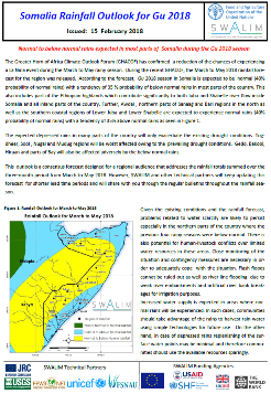
Somalia GU 2018 Rainfall Outlook
The Greater Horn of Africa Climate Outlook Forum (GHACOF) has confirmed a reduction of the chances of experiencing a La Nina event during the March to May rainy season. During the recent GHACOF, the March to May 2018 rainfall forecast for the region was released. According to the forecast, Gu 2018 season in Somalia is expected to be normal (40% probability of normal rains) with a tendency of 35 % probability of below normal rains in most parts of the country. This also includes part of the Ethiopian highlands which contribute significantly to both Juba and Shabelle river flow inside Somalia and all inland parts of the country. Further, Awdal , northern parts of Sanaag and Bari regions in the north as well as the southern coastal regions of Lower Juba and Lower Shabelle are expected to experience normal rains (40% probability of normal rains) with a tendency of 35% above normal rains..
The expected depressed rains in many parts of the country will only exacerbate the existing drought conditions. Togdheer, Sool , Nugal and Mudug regions will be worst affected owing to the prevailing drought conditions. Gedo, Bakool, Hiraan and parts of Bay will also be affected adversely by the below normal rains.
This outlook is a consensus forecast designed for a regional audience that addresses the rainfall totals summed over the three-month period from March to May 2018. However, SWALIM and other technical partners will keep updating this forecast for shorter lead time periods and will share with you through the regular bulletins throughout the rainfall season.
For more information, please find attached the Somalia Gu 2018 rainfall outlook bulletin.
Publication Type:
Rainfall Outlook
Publication Date:
Author:
Corporate Author:
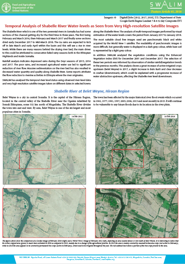
Temporal Analysis of Shabelle River Water-levels as Seen from Very High-resolution Satellite Images
The Shabelle River which is one of the two perennial rivers in Somalia has had some sections of the channel getting dry for the third time in three years. The first being February and March 2016, then February and March 2017 and finally some sections dried early December 2017 to Mid-March 2018. The Gu rains are expected to kick off in late March and early April within the basin and this will see a rise in river levels. While there are many reasons behind the drying river bed, the main driver to this could be attributed to consecutive failed rainy seasons both in the Ethiopian Highlands and inside Somalia.
Rainfall analysis indicates depressed rains during the Deyr seasons of 2015, 2016 and 2017. The poor rains, and increased agricultural water use led to significant reduction of river flow. Massive sedimentation on the river bed has also resulted in decreased water quantity and quality along Shabelle River. Some reports attribute the flow reduction to riverine activities in Ethiopia where the river originates.
SWALIM has analysed the temporal river level status using observed river level data and very high-resolution satellite images taken on different dates in selected towns along the Shabelle River. The analysis of multi-temporal images performed by visual estimation of the water levels covers the period from January 2017 to January 2018.
The most suitable cloud free images used are panchromatic black and white acquired by the World View 1 satellite. The readability of panchromatic images is more difficult, but generally water is displayed in a dark grey colour, while bare soil is represented by a light grey colour.
In addition SWALIM analyzed the vegetation conditions using the Enhanced Vegetation Index (EVI) for December 2001 and December 2017. The selection of these two periods was informed by observation of similar rainfall/vegetation trends in the previous months. This analysis shows a great increase of active irrigated crops upstream (Belet Weyne) in 2017, a slight increase in Bulo Burti and clear decrease in Jowhar (downstream), which could be explained with a progressive increase of water abstraction upstream, affecting the Shabelle river level downstream.
Publication Type:
Brochure
Publication Date:
Author:
Corporate Author:
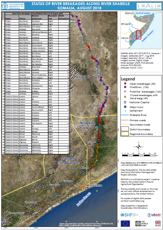
Status of River Breakages Along Shabelle River as at August 2018
Recurrent flooding along the Shabelle River in Southern Somalia has been one of the key challenges for agencies involved in community development in the area. The Shabelle River is worst affected owing to the topography of the area, uncontrolled irrigation activities and poor river basin management following the collapse of pre-war flood control infrastructure. The Gu 2018 rainy season which was characterised by heavy rains inside Somalia and the Ethiopian highlands led to a significant increase of river levels subsequently leading to river flooding that caused agricultural and economic damage in the Shabelle river basin.
SWALIM, has been involved in analysing and mapping the river breakages along the Shabelle River using very high resolution (sub meter) satellite imagery and a Digital Elevation Model (DEM) derived from earlier acquired aerial photographs having 3 meter resolution.
Four types of breakages have been identified along Shabelle River namely; Open, Overflow, Potential and Closed. The open breakages are those that were still open during the month of July 2018. The Overflow, indicates points where there has been recent river spillage causing extensive flooding. The potential breakages represent points that have very weak river embankments or have experienced several breakages in the recent past. The closed breakages are those that were previously open but efforts have been made to close them either with sand bags or heavy machinery.
The attached table provides locations of both Open and Overflow points along the Shabelle River which require immediate attention. A total of 50 Open points have been identified which is 100% increase from the previous assessment carried out in March 2018 (Refer to the attached table for estimated width of the open breakages). The sharp increase is due to the heavy rains of Gu 2018 rainy season that led to river breakages. 126 Overflow (Overbank river spillage) points have also been identified. The estimated cumulative length of the Overflow sections along the river bank is approximately 82.6 km whose calculation is derived from visible spillages and fresh sand deposits during the flooding period. Several other points, which are either potential or temporarily closed with sandbags, have also been identified.
With the Deyr rains expected in October and November 2018, river levels will increase with a likelihood of flooding especially where open and overflow points have been identified. There is therefore an immediate need to close the open points and reinforce areas where there are weak river embankments.
Maps of the status of river breakages, with detailed information, have been produced at large scale and hard copies can be obtained from SWALIM offices or by email request through swalim@fao.org
It is worth noting that the methodology is biased towards Remote Sensing (RS) interpretation with only limited “ground truthing” due to access constraints. Open breakages and overflows might have been omitted in some cases where satellite images were not available or may not have been very clear due to heavy cloud cover.
Publication Type:
Map
Publication Date:
Author:
Corporate Author:
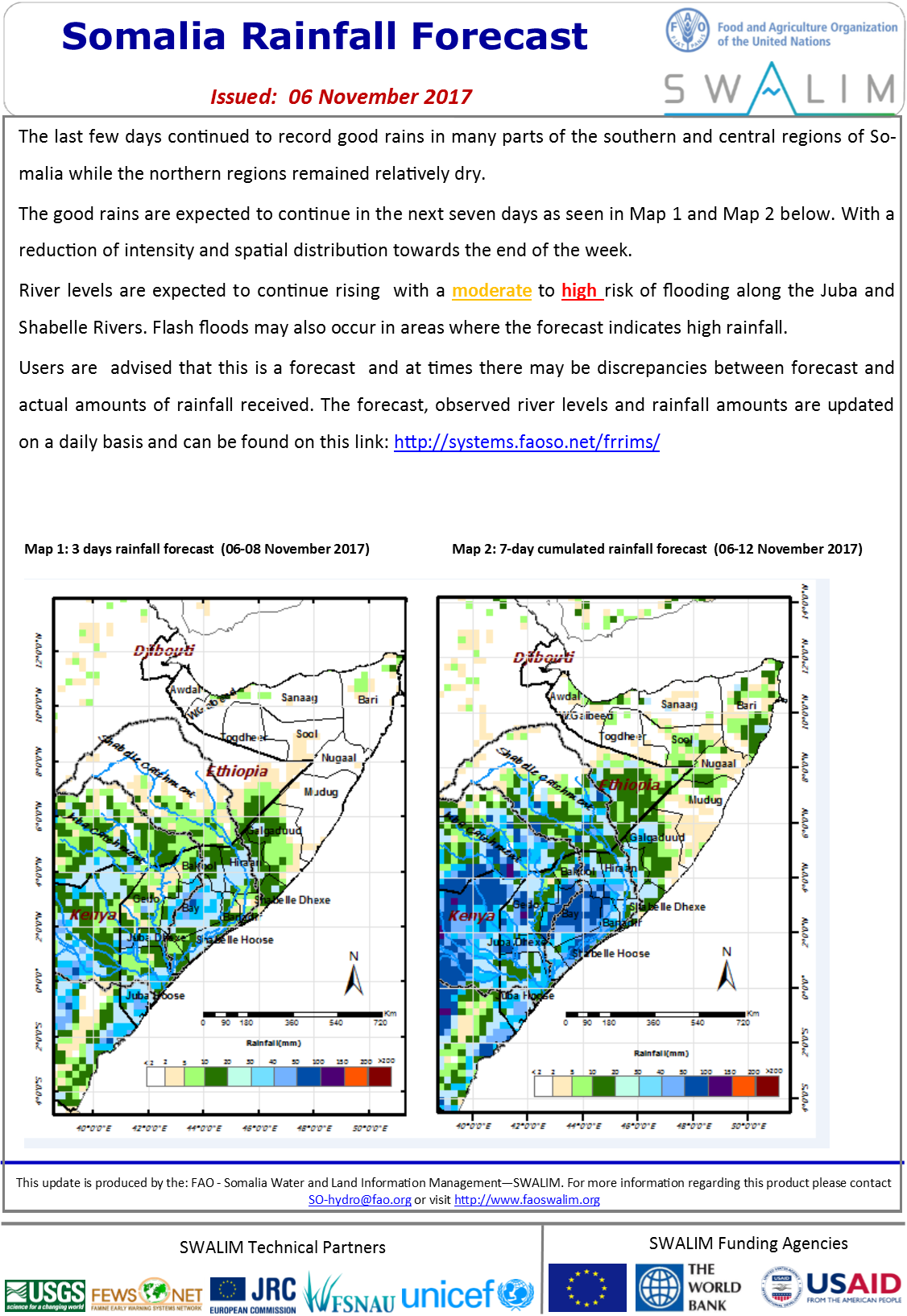
Somalia Rainfall Forecast 06-11-2017
The last few days continued to record good rains in many parts of the southern and central regions of Somalia while the northern regions remained relatively dry.
The good rains are expected to continue in the next seven days. With a reduction of intensity and spatial distribution towards the end of the week.
River levels are expected to continue rising with a moderate to high risk of flooding along the Juba and Shabelle Rivers. Flash floods may also occur in areas where the forecast indicates high rainfall.
Publication Type:
Rainfall Forecast
Publication Date:
Author:
Corporate Author:

Somalia Rainfall Forecast 13-11-2017
The last 10 days have seen extremely heavy rains in some parts of southern and central regions of Somalia causing flooding and displacements in a few places. Bay region saw the heaviest amounts of rainfall with some station surpassing the annual average rains in a few days.
Rainfall activities are expected to decrease in the coming week given the 3 days and one week rainfall forecasts. There remains a moderate to high risk of flooding in the middle and lower reaches of both Juba and Shabelle rivers where the river levels are currently very high.
Publication Type:
Rainfall Forecast
Publication Date:
Author:
Corporate Author:
Saadaasha Roob-di’idda Soomaaliya 06-11-2017
Roobab fudfudud ayaa lagu arkayaa inay ka sii socdaan dhawr meelood oo ku kala durdurugsa gudaha dalka oo idil intii lagu jirey dhawrkii maalmood oo dambe.
Saadaasha roob-di’idda la isugeeyey ee saddexda maalmood oo soo scota (Khariidadda 1) waxay muujineysaa koror la filayo oo roob-di’id ah gaar ahaan gudaha gobollada Soomaaliya ee Mudug, Galguduud, Hiiraan, Bay iyo Bakool iyo Buuraleyda sare ee Itoobiya. Xaddiga roobabka waxaa la filayaa inn uu ku sii faafo bed/masaaxad ahaan iyo tiro ahaan markii toddobaadku sii socdo oo loo gudbo toddobada maalmood ee saadaasha roob-di’idda (Khariidadda 2).
Sidaa awgeed, heerarka webiga ayaa la filayaa inay sii kordhaan taaasoo ku keeni karta halis fatahaad bartamaha iyo dhanka hoose ee labada webi Jubba iyo Shabeelle ilaa dhammaadka toddobaadka. Daadadka ayaa sidoo kale laga yaabaa inay ka dhacaan meelaha ay saadaashu ku tilmaameyso roob-di’id badan.
Publication Type:
Rainfall Forecast
Publication Date:
Author:
Corporate Author:
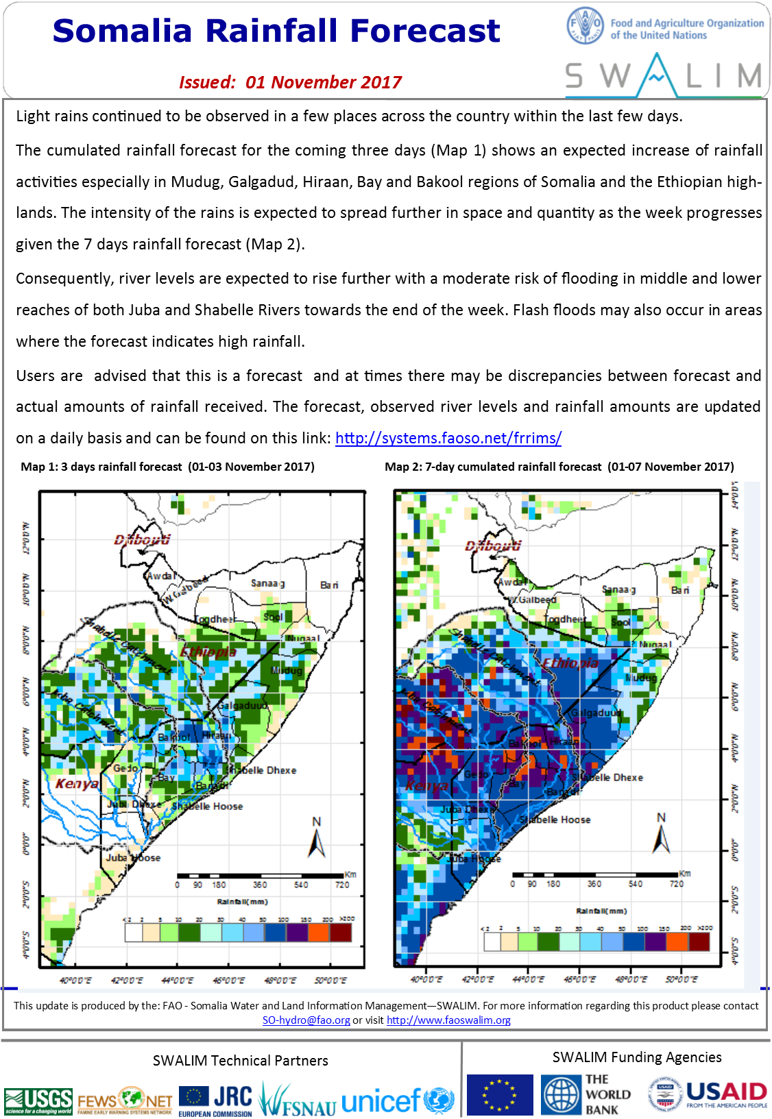
Somalia Rainfall Forecast 01-11-2017
Light rains continued to be observed in a few places across the country within the last few days.
The cumulated rainfall forecast for the coming three days shows an expected increase of rainfall activities especially in Mudug, Galgadud, Hiraan, Bay and Bakool regions of Somalia and the Ethiopian highlands. The intensity of the rains is expected to spread further in space and quantity as the week progresses given the 7 days rainfall forecast.
Consequently, river levels are expected to rise further with a moderate risk of flooding in middle and lower reaches of both Juba and Shabelle Rivers towards the end of the week. Flash floods may also occur in areas where the forecast indicates high rainfall.
Users are advised that this is a forecast and at times there may be discrepancies between forecast and actual amounts of rainfall received. The forecast, observed river levels and rainfall amounts are updated on a daily basis and can be found on this link: http://systems.faoso.net/frrims/
Publication Type:
Rainfall Forecast
Publication Date:
Author:
Corporate Author:
Pages
 RSS feed [compliant with the Agris AP] |
  Agris AP XML