Library Catalog
Latest Documents and Publications listed. Use search terms in the box below to find what you need
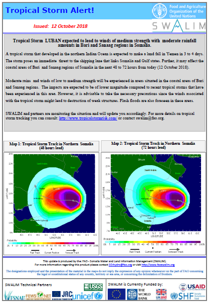
Tropical Storm Alert - Issued 12 October 2018
Tropical Storm LUBAN expected to lead to winds of medium strength with moderate rainfall amounts in Bari and Sanaag regions in Somalia.
A tropical storm that developed in the northern Indian Ocean is expected to make a land fall in Yemen in 3 to 4 days. The storm poses an immediate threat to the shipping lane that links Somalia and Gulf states. Further, it may affect the coastal areas of Bari and Sanaag regions of Somalia in the next 48 to 72 hours from today (12 October 2018).
Moderate rains and winds of low to medium strength will be experienced in areas situated in the coastal areas of Bari and Sanaag regions. The impacts are expected to be of lower magnitude compared to recent tropical storms that have been experienced in this area. However, it is advisable to take the necessary precautions since the winds associated with the tropical storm might lead to destruction of weak structures. Flash floods are also foreseen in these areas.
SWALIM and partners are monitoring the situation and will update you accordingly. For more details on tropical storm tracking you can consult: http://www.tropicalstormrisk.com/ or contact swalim@fao.org.
Publication Type:
Flood Alert
Publication Date:
Author:
Corporate Author:
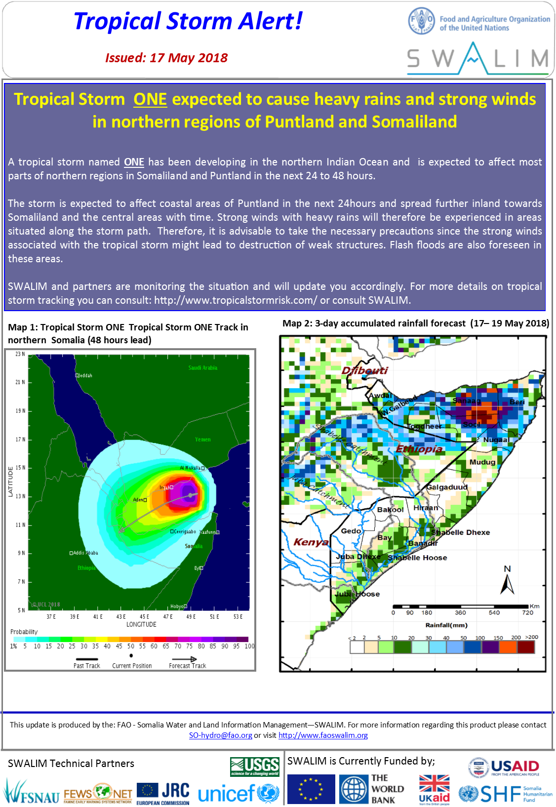
Tropical Storm Alert - Issued 17 May 2018
A tropical storm named ONE has been developing in the northern Indian Ocean and is expected to affect most parts of northern regions in Somaliland and Puntland in the next 24 to 48 hours.
The storm is expected to affect coastal areas of Puntland in the next 24hours and spread further inland towards Somaliland and the central areas with time. Strong winds with heavy rains will therefore be experienced in areas situated along the storm path. Therefore, it is advisable to take the necessary precautions since the strong winds associated with the tropical storm might lead to destruction of weak structures. Flash floods are also foreseen in these areas.
SWALIM and partners are monitoring the situation and will update you accordingly. For more details on tropical storm tracking you can consult: http://www.tropicalstormrisk.com/ or consult us through swalim@fao.org.
Publication Type:
Storm Alert
Publication Date:
Author:
Corporate Author:
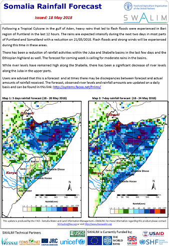
Somalia Rainfall Forecast - Issued 18 May 2018
Following a Tropical Cylcone in the gulf of Aden, heavy rains that led to flash floods were experienced in Bari region of Puntland in the last 12 hours. The rains are expected intensify during the next two days in most parts of Puntland and Somaliland with a reduction on 21/05/2018. Flash floods and strong winds will be experienced during this time in these areas.
There has been a reduction of rainfall activities within the Juba and Shabelle basins in the last few days and the Ethiopian highland as well. The forecast for coming week is calling for moderate rains in the basins.
While river levels have remained high along the Shabelle, there has been a significant decrease of river levels along the Juba in the upper parts.
Publication Type:
Rainfall Forecast
Publication Date:
Author:
Corporate Author:
Somalia Gu Rainfall Performance Update May 2018
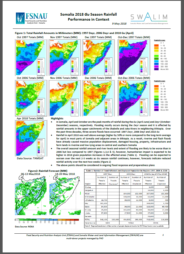
Rainfall in April 2018 was well above average (higher by 50% or more compared to the long-term average for April) in most parts of Somalia and adjacent areas in Ethiopia. As a result, riverine and flash floods have already caused massive population displacement, damaged housing, property, infrastructure and farm lands in riverine and low-lying areas in central and southern Somalia
The overall seasonal rainfall amount and river levels and extent of flooding are likely to be worse than in 2006 but less compared to 1997; however, humanitarian impact is expected to be higher in 2018 given population increases in the affected areas. Flooding can be expected to worsen over the next 2-3 weeks as Gu season rainfall continues; however, forecasts indicate reduced rainfall activity over the next two weeks.
Publication Type:
Rainfall Performance
Publication Date:
Author:
Corporate Author:
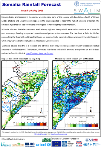
Somalia Rainfall Forecast - Issued 10 may 2018
With the high water levels and over bank spillage in Belt Weyne, River levels at Bulo Burti are fast approaching the high risk threshold. The high water levels are expected to be transmitted to Middle and Lower Shabelle in the next couple of days and this is likely to worsen the flood situation in these areas.
Communities residing in the riverine areas of Middle and Lower Shabelle, in particular, are requested to be on the alert for rising river levels and possible overspill. All necessary measures should be taken to preserve life and property in these areas.
Publication Type:
Rainfall Forecast
Publication Date:
Author:
Corporate Author:
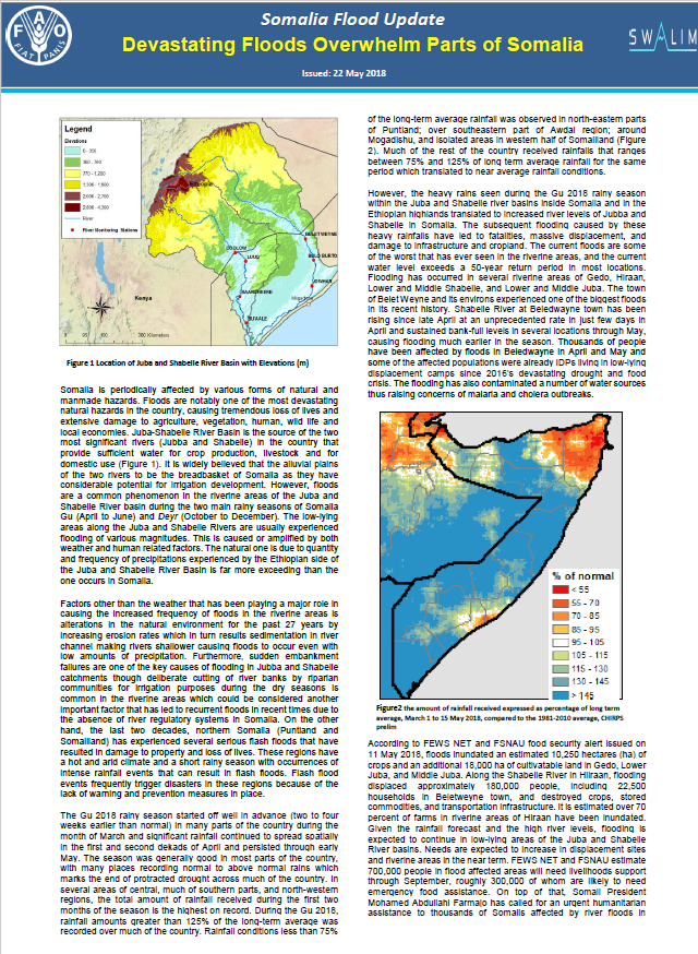
Devastating floods Overwhelm parts of Somalia
Somalia is periodically affected by various forms of natural and manmade hazards. Floods are notably one of the most devastating natural hazards in the country, causing tremendous loss of lives and extensive damage to agriculture, vegetation, human, wild life and local economies.
Juba-Shabelle River Basin is the source of the two most significant rivers (Jubba and Shabelle) in the country that provide sufficient water for crop production, livestock and for domestic use (Figure 1). It is widely believed that the alluvial plains of the two rivers to be the breadbasket of Somalia as they have considerable potential for irrigation development. However, floods are a common phenomenon in the riverine areas of the Juba and Shabelle River basin during the two main rainy seasons of Somalia Gu (April to June) and Deyr (October to December). The low-lying areas along the Juba and Shabelle Rivers are usually experienced flooding of various magnitudes. This is caused or amplified by both weather and human related factors. The natural one is due to quantity and frequency of precipitations experienced by the Ethiopian side of the Juba and Shabelle River Basin is far more exceeding than the one occurs in Somalia.
Publication Type:
Flood watch bulletin
Publication Date:
Author:
Corporate Author:
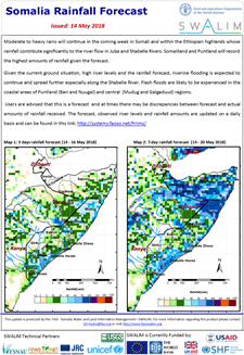
Somalia Rainfall Forecast - Issued 14 May 2018
Moderate to heavy rains will continue in the coming week in Somali and within the Ethiopian highlands whose rainfall contribute significantly to the river flow in Juba and Shabelle Rivers. Somaliland and Puntland will record the highest amounts of rainfall given the forecast.
Given the current ground situation, high river levels and the rainfall forecast, riverine flooding is expected to continue and spread further especially along the Shabelle River. Flash floods are likely to be experienced in the coastal areas of Puntland (Bari and Nuugal) and central (Mudug and Galgaduud) regions.
Publication Type:
Rainfall Forecast
Publication Date:
Author:
Corporate Author:
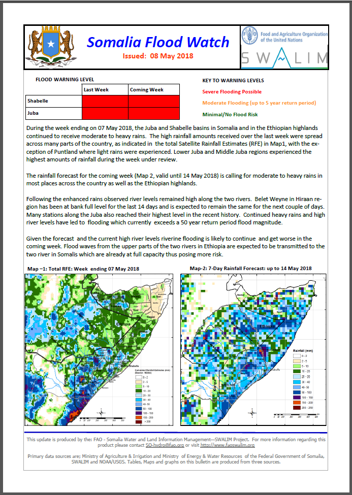
Somalia Flood Watch Bulletin - Issued 08 May 2018
The rainfall forecast for the coming week is calling for moderate to heavy rains in most places across the country as well as the Ethiopian highlands.
Following the enhanced rains observed river levels remained high along the two rivers. Belet Weyne in Hiraan region has been at bank full level for the last 14 days and is expected to remain the same for the next couple of days. Many stations along the Juba also reached their highest level in the recent history. Continued heavy rains and high river levels have led to flooding which currently exceeds a 50 year return period flood magnitude.
Publication Type:
Flood watch bulletin
Publication Date:
Author:
Corporate Author:
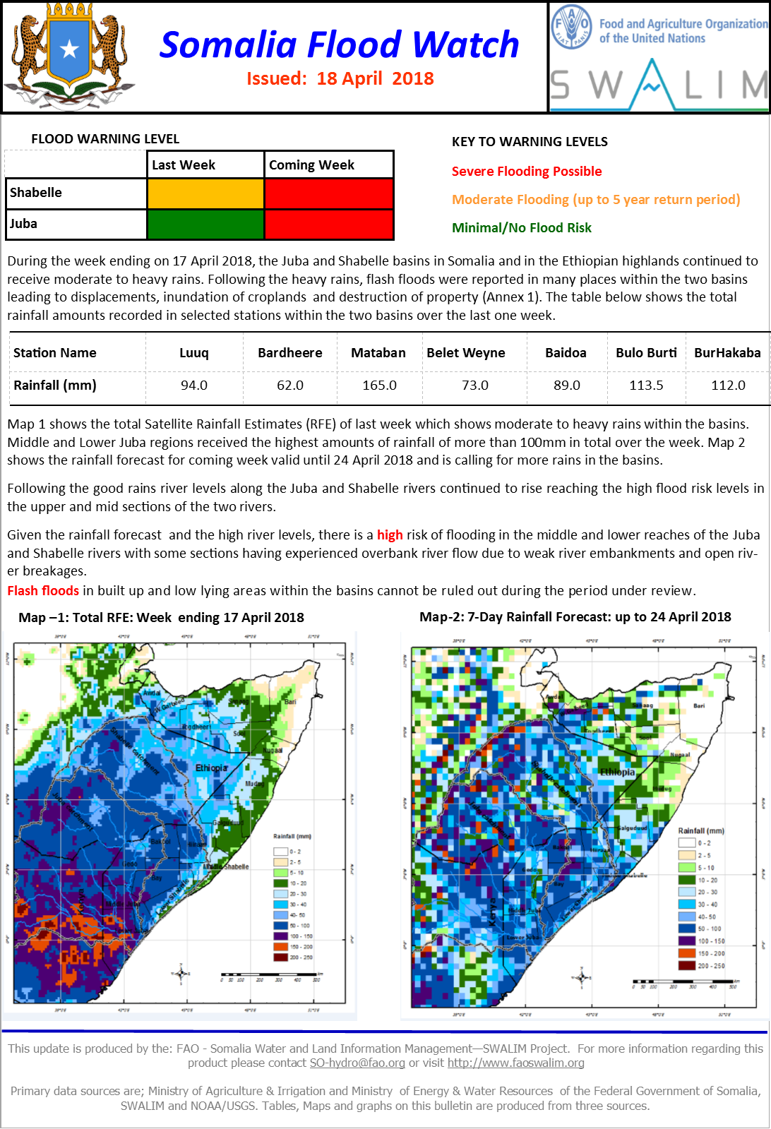
Somalia Flood Watch Bulletin - Issued: 18 April 2018
During the week ending on 17 April 2018, the Juba and Shabelle basins in Somalia and in the Ethiopian highlands continued to receive moderate to heavy rains. Following the heavy rains, flash floods were reported in many places within the two basins leading to displacements, inundation of croplands and destruction of property. The table below shows the total rainfall amounts recorded in selected stations within the two basins over the last one week.
Map 1 shows the total Satellite Rainfall Estimates (RFE) of last week which shows moderate to heavy rains within the basins. Middle and Lower Juba regions received the highest amounts of rainfall of more than 100mm in total over the week. Map 2 shows the rainfall forecast for coming week valid until 24 April 2018 and is calling for more rains in the basins.
Following the good rains river levels along the Juba and Shabelle rivers continued to rise reaching the high flood risk levels in the upper and mid sections of the two rivers.
Given the rainfall forecast and the high river levels, there is a high risk of flooding in the middle and lower reaches of the Juba and Shabelle rivers with some sections having experienced overbank river flow due to weak river embankments and open river breakages.
Flash floods in built up and low lying areas within the basins cannot be ruled out during the period under review
Publication Type:
Flood watch bulletin
Publication Date:
Author:
Corporate Author:

Validation of the CHIRPS satellite rainfall estimates over eastern Africa
Long and temporally consistent rainfall time series are essential in climate analyses and applications. Rainfall data from station observations are inadequate over many parts of the world due to sparse or non‐existent observation networks, or limited reporting of gauge observations. As a result, satellite rainfall estimates have been used as an alternative or as a supplement to station observations. However, many satellite‐based rainfall products with long time series suffer from coarse spatial and temporal resolutions and inhomogeneities caused by variations in satellite inputs. There are some satellite rainfall products with reasonably consistent time series, but they are often limited to specific geographic areas. The Climate Hazards Group Infrared Precipitation (CHIRP) and CHIRP combined with station observations (CHIRPS) are recently produced satellite‐based rainfall products with relatively high spatial and temporal resolutions and quasi‐global coverage. In this study, CHIRP and CHIRPS were evaluated over East Africa at daily, dekadal (10‐day) and monthly time‐scales. The evaluation was done by comparing the satellite products with rain‐gauge data from about 1,200 stations. The CHIRP and CHIRPS products were also compared with two similar operational satellite rainfall products: the African Rainfall Climatology version 2 (ARC2) and the Tropical Applications of Meteorology using Satellite data (TAMSAT). The results show that both CHIRP and CHIRPS products are significantly better than ARC2 with higher skill and low or no bias. These products were also found to be slightly better than the latest version of the TAMSAT product at dekadal and monthly time‐scales, while TAMSAT performed better at the daily time‐scale. The performance of the different satellite products exhibits high spatial variability with weak performances over coastal and mountainous regions.
Publication Type:
Journal Article
Publication Date:
Author:
Chris Funk, Tufa Dinku, Gadain H.M.
Corporate Author:
Pages
 RSS feed [compliant with the Agris AP] |
  Agris AP XML