Library Catalog
Latest Documents and Publications listed. Use search terms in the box below to find what you need
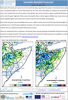
Somalia Rainfall Forecast: Issued 16-04-2019
Drought conditions persisted in most parts of the country during the first half of April. Pasture and water are in poor conditions and close to depletion in most areas of key pastoral livelihoods across Somalia. Significant rainfall amounts with good temporal distribution will be required to reverse the current state.
The Gu rains normally start in late March in the north western parts of the country and late March / early April in the rest of the country. However, the rains came late in north western regions, and are yet to start in many other parts of the country, which creates doubts among the humanitarian actors in Somalia about the future food security and water availability.
Local oceanic systems including the recent cyclones around Mozambique have weakened the rainfall generating mechanism in Somalia and the Horn of Africa in general.
River levels increased slightly over the last few days following rains in the Ethiopian highlands. The levels are however below their normal in both Juba and Shabelle rivers during this time of the year.
Publication Type:
Rainfall Forecast
Publication Date:
Author:
Corporate Author:
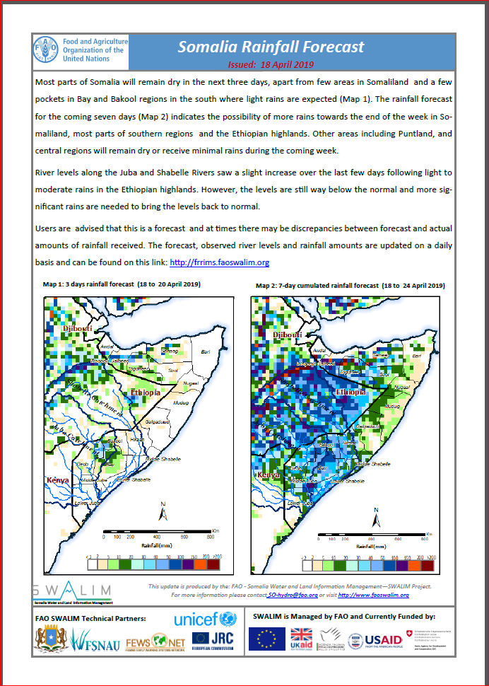
Somalia Rainfall Forecast: Issued 18-04-2019
Most parts of Somalia will remain dry in the next three days, apart from few areas in Somaliland and a few pockets in Bay and Bakool regions in the south where light rains are expected. The rainfall forecast for the coming seven days indicates the possibility of more rains towards the end of the week in Somaliland, most parts of southern regions and the Ethiopian highlands. Other areas including Puntland, and central regions will remain dry or receive minimal rains during the coming week.
River levels along the Juba and Shabelle Rivers saw a slight increase over the last few days following light to moderate rains in the Ethiopian highlands. However, the levels are still way below the normal and more significant rains are needed to bring the levels back to normal.
Publication Type:
Rainfall Forecast
Publication Date:
Author:
Corporate Author:
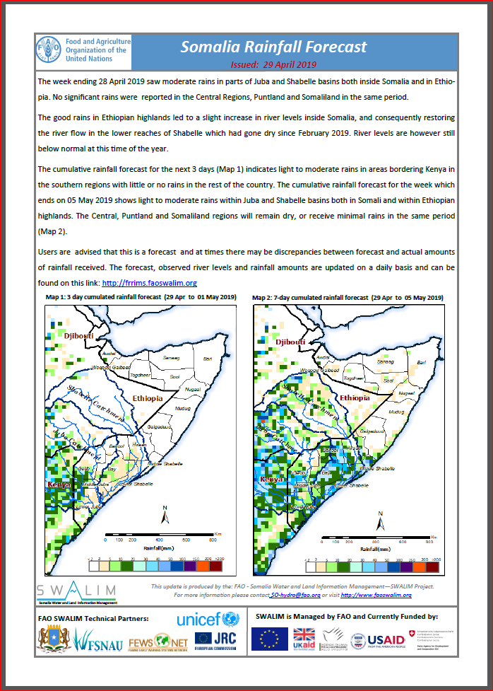
Somalia Rainfall Forecast: Issued 29-04-2019
The week ending 28 April 2019 saw moderate rains in parts of Juba and Shabelle basins both inside Somalia and in Ethiopia. No significant rains were reported in the Central Regions, Puntland and Somaliland in the same period.
The good rains in Ethiopian highlands led to a slight increase in river levels inside Somalia, and consequently restoring the river flow in the lower reaches of Shabelle which had gone dry since February 2019. River levels are however still below normal at this time of the year.
The cumulative rainfall forecast for the next 3 days indicates light to moderate rains in areas bordering Kenya in the southern regions with little or no rains in the rest of the country. The cumulative rainfall forecast for the week which ends on 05 May 2019 shows light to moderate rains within Juba and Shabelle basins both in Somali and within Ethiopian highlands. The Central, Puntland and Somaliland regions will remain dry, or receive minimal rains in the same period.
Publication Type:
Rainfall Forecast
Publication Date:
Author:
Corporate Author:
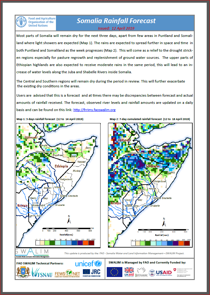
Somalia Rainfall Forecast: Issued 12-04-2019
Most parts of Somalia will remain dry for the next three days, apart from few areas in Puntland and Somaliland where light showers are expected. The rains are expected to spread further in space and time in both Puntland and Somaliland as the week progresses. This will come as a relief to the drought stricken regions especially for pasture regrowth and replenishment of ground water sources. The upper parts of Ethiopian highlands are also expected to receive moderate rains in the same period, this will lead to an increase of water levels along the Juba and Shabelle Rivers inside Somalia.
The Central and Southern regions will remain dry during the period in review. This will further exacerbate the existing dry conditions in the areas.
Publication Type:
Rainfall Forecast
Publication Date:
Author:
Corporate Author:
Update on rainfall river level and likely impact - Issued 11 April 2019
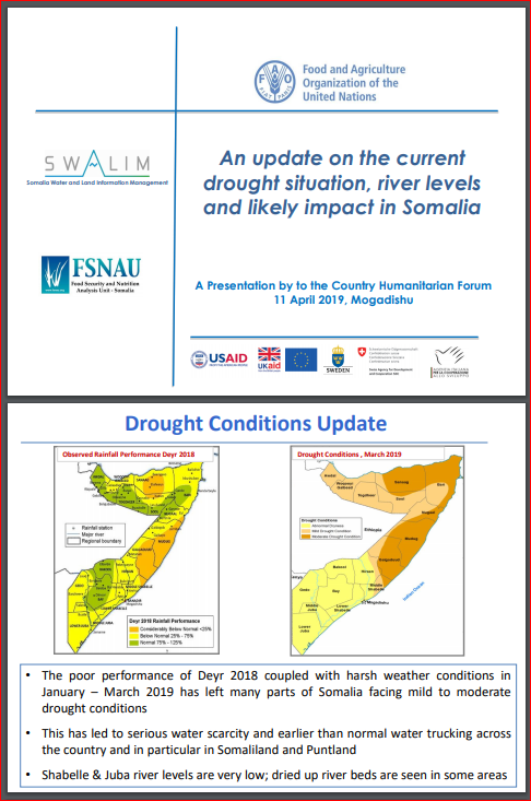
The poor performance of Deyr 2018 coupled with harsh weather conditions in January – March 2019 has left many parts of Somalia facing mild to moderate drought conditions.
This has led to serious water scarcity and earlier than normal water trucking across the country and in particular in Somaliland and Puntland.
Shabelle & Juba river levels are very low; dried up river beds are seen in some areas.
Publication Type:
Publication Date:
Author:
Corporate Author:
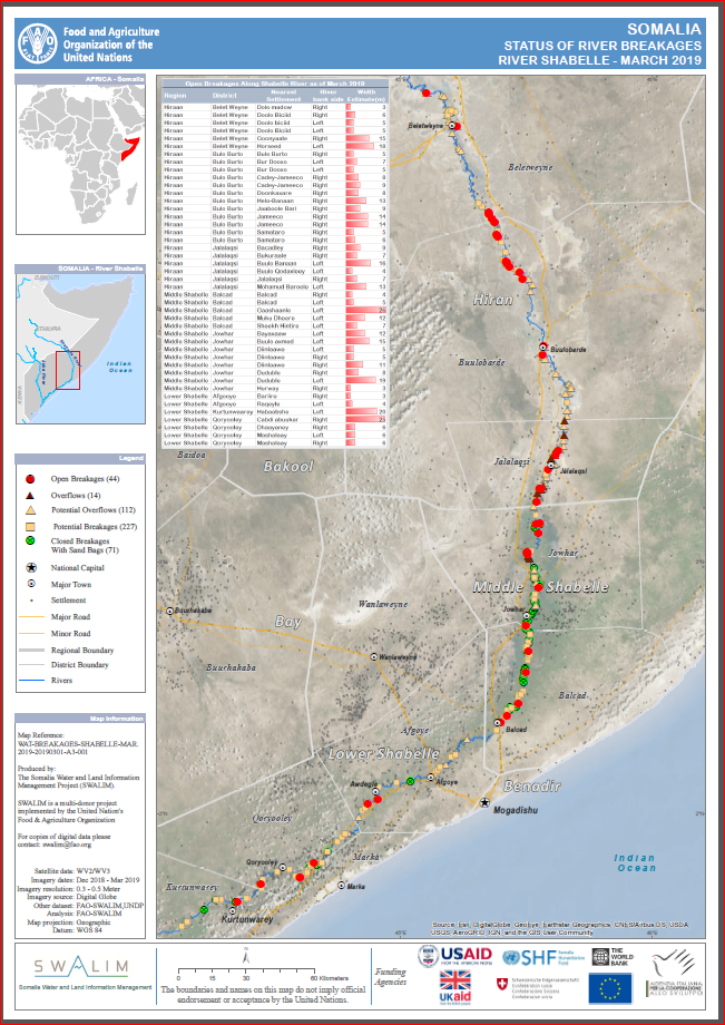
Status of River Breakages Shabelle March 2019
Following a poor rainfall season of Deyr 2018 (Oct – Dec) within the Juba and Shabelle river basins the river flows of the two rivers have since been significantly below normal. Reports indicate of drying river beds in some section of the Shabelle River during the month of February 2019. The situation is expected to improve in April given the GU 2019 rainfall forecast which calls for good rains within the catchments.
FAO through SWALIM, has been involved in analysing and mapping the river breakages along the Shabelle River using very high resolution (sub meter) satellite imagery and a Digital Elevation Model (DEM) derived from earlier acquired aerial photographs having 3 meter resolution.
Five types of breakages have been identified along Shabelle River namely; Open, Overflow, Potential Overflows, Potential breakages and Closed. The open breakages are those that were still open according to the latest satellite image analysed . The Overflow, indicates points where there has been recent river spillage causing extensive flooding. The potential overflows are those points that have high likelihood of overbank spillage but not overflowing at the time of analysis due to low river flows. The Potential breakages represent points that have very weak river embankments or have experienced several breakages in the past. The closed breakages are those that were previously open but efforts have been made to close them either with sand bags or heavy machinery.
A total of 88 Open points have been identified, 44 on each river. In addition, 14 overflow points have been identified along the Shabelle River and none along the Juba River. More overflows could be expected when rivers level rises above normal rate. Several other points, which are either potential or temporarily closed with sandbags, have also been identified.
With the Gu rains expected in April 2019, river levels will increase with a likelihood of flooding especially where open and overflow points have been identified. There is therefore an immediate need to close the open points and reinforce areas where there are weak river embankments. Temporary measures can be taken before the season begins.
Maps of the status of river breakages along the two rivers, with detailed information, have been produced at large scale and hardcopies can be obtained from FAO SWALIM offices. This information is also available on the SWALIM website.
It is worth noting that the methodology is biased towards Remote Sensing (RS) interpretation with only limited “ground truthing” due to access constraints. Open breakages and overflows might have been omitted or classified as potential in some cases where satellite images were not available or may not have been very clear due to heavy cloud cover and dense vegetation cover.
Publication Type:
Publication Date:
Author:
Corporate Author:
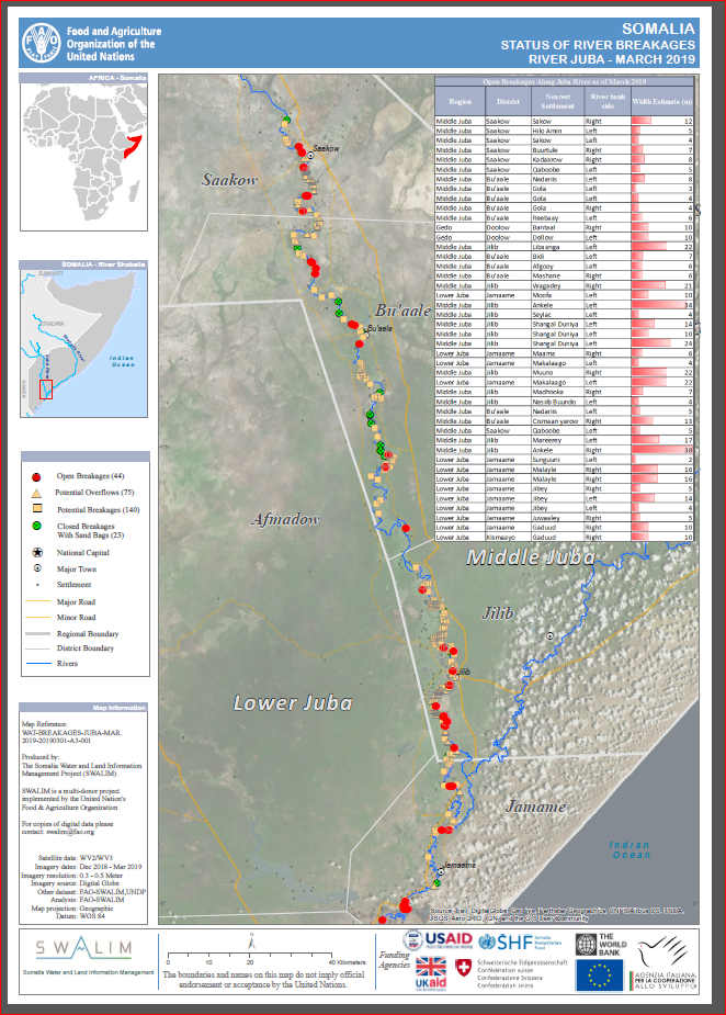
Status of River Breakages Juba March 2019
Following a poor rainfall season of Deyr 2018 (Oct – Dec) within the Juba and Shabelle river basins the river flows of the two rivers have since been significantly below normal. Reports indicate of drying river beds in some section of the Shabelle River during the month of February 2019. The situation is expected to improve in April given the GU 2019 rainfall forecast which calls for good rains within the catchments.
FAO through SWALIM, has been involved in analysing and mapping the river breakages along the Shabelle River using very high resolution (sub meter) satellite imagery and a Digital Elevation Model (DEM) derived from earlier acquired aerial photographs having 3 meter resolution.
Five types of breakages have been identified along Shabelle River namely; Open, Overflow, Potential Overflows, Potential breakages and Closed. The open breakages are those that were still open according to the latest satellite image analysed . The Overflow, indicates points where there has been recent river spillage causing extensive flooding. The potential overflows are those points that have high likelihood of overbank spillage but not overflowing at the time of analysis due to low river flows. The Potential breakages represent points that have very weak river embankments or have experienced several breakages in the past. The closed breakages are those that were previously open but efforts have been made to close them either with sand bags or heavy machinery.
A total of 88 Open points have been identified, 44 on each river. In addition, 14 overflow points have been identified along the Shabelle River and none along the Juba River. More overflows could be expected when rivers level rises above normal rate. Several other points, which are either potential or temporarily closed with sandbags, have also been identified.
With the Gu rains expected in April 2019, river levels will increase with a likelihood of flooding especially where open and overflow points have been identified. There is therefore an immediate need to close the open points and reinforce areas where there are weak river embankments. Temporary measures can be taken before the season begins.
Maps of the status of river breakages along the two rivers, with detailed information, have been produced at large scale and hardcopies can be obtained from FAO SWALIM offices. This information is also available on the SWALIM website.
It is worth noting that the methodology is biased towards Remote Sensing (RS) interpretation with only limited “ground truthing” due to access constraints. Open breakages and overflows might have been omitted or classified as potential in some cases where satellite images were not available or may not have been very clear due to heavy cloud cover and dense vegetation cover.
Publication Type:
Publication Date:
Author:
Corporate Author:
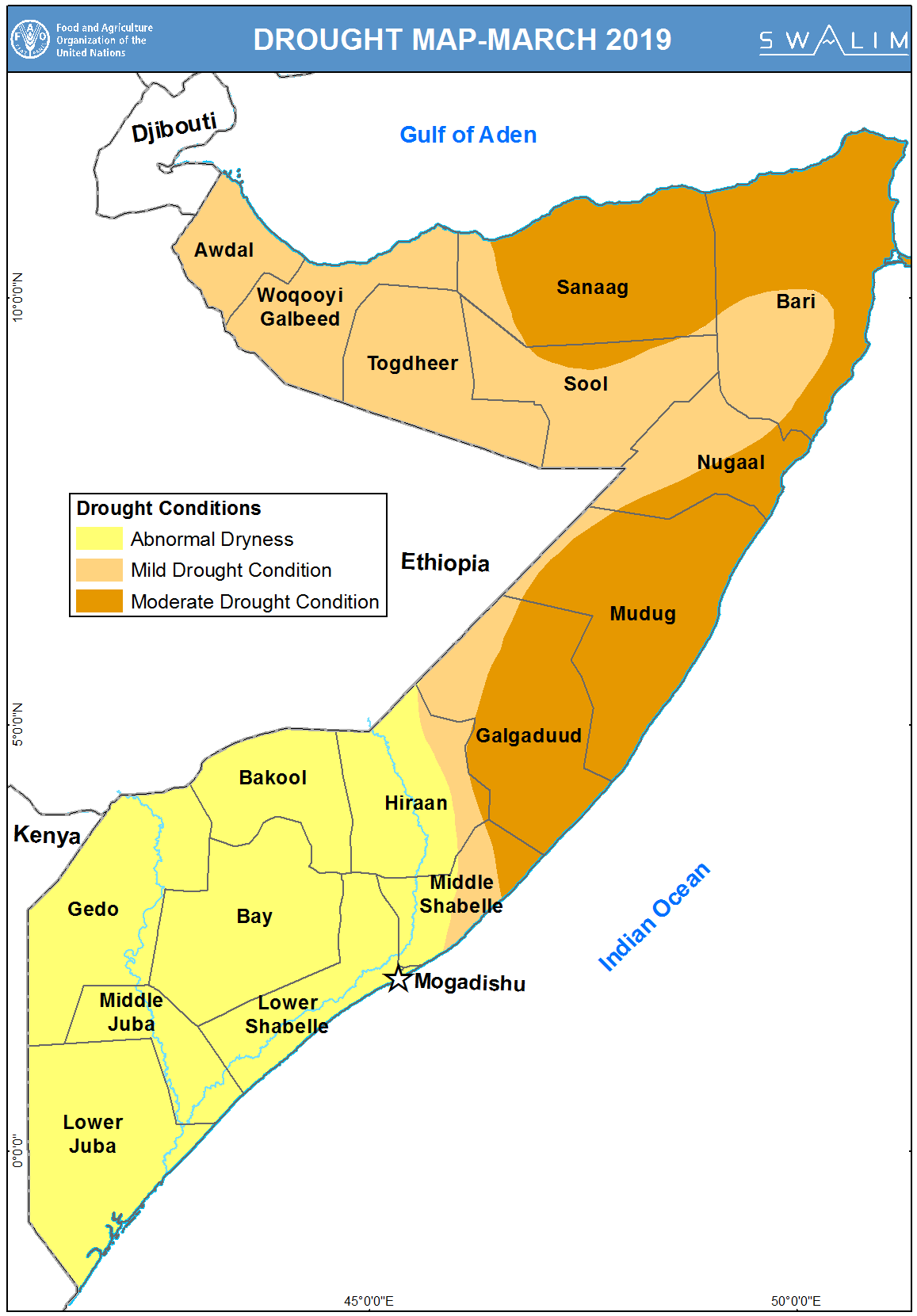
Somalia Drought Watch Bulletin - Issued 26 Mar 2019
The much anticipated Gu rains in Somalia may experience a delay owing to the ongoing cyclonic systems in southern Indian Ocean. The ocean systems have delayed the northward movement of the rain bearing zone – Inter Tropical Convergence Zone (ITCZ). Further, this has reduced the influx of moisture expected in the East African countries including Kenya and Somalia.
Following a poor Deyr 2018 season many parts of the countries have experienced prolonged dry periods that have led to mild to moderate drought conditions in the country. The worst affected areas being north eastern parts of Puntland central regions.
Publication Type:
Drought watch
Publication Date:
Author:
Corporate Author:
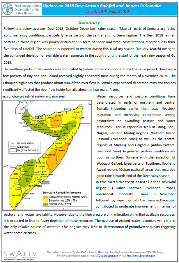
Update on 2018 Deyr Season Rainfall and Impact in Somalia
Following a below average Deyr 2018 (October-December) rainy season (Map 1) parts of Somalia are facing abnormally dry conditions, particularly large parts of the central and northern regions. The Deyr 2018 rainfall pattern in these region was poorly distributed in term of space and time. Most stations recorded less than five days of rainfall. The situation is expected to worsen during this Jilaal dry season (January–March) owing to the continued depletion of available water resources in the country until the start of the next rainy season of Gu 2019.
The southern parts of the country was dominated by below normal conditions during the same period, However, a few pockets of Bay and and Bakool received slightly enhanced rains during the month of November 2018. The Ethiopian highlands that produce about 90% of the river flow in Somalia experienced depressed rains and this has significantly affected the river flow inside Somalia along the two major Rivers.
Publication Type:
Publication Date:
Author:
Corporate Author:
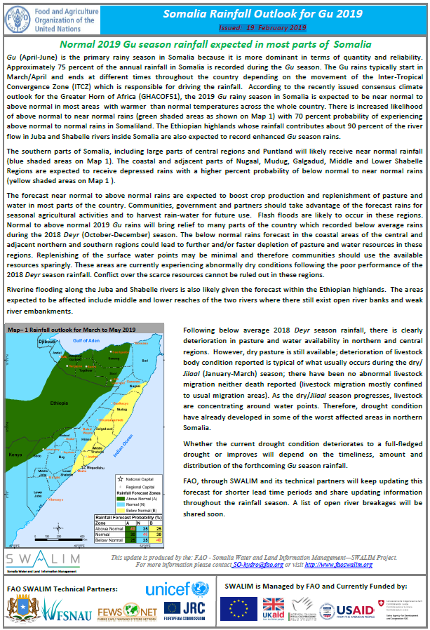
Somalia Rainfall Outlook for Gu 2019 - Issued: 19 February 2019
Gu (April-June) is the primary rainy season in Somalia because it is more dominant in terms of quantity and reliability. Approximately 75 percent of the annual rainfall in Somalia is recorded during the Gu season. The Gu rains typically start in March/April and ends at different times throughout the country depending on the movement of the Inter-Tropical Convergence Zone (ITCZ) which is responsible for driving the rainfall. According to the recently issued consensus climate outlook for the Greater Horn of Africa (GHACOF51), the 2019 Gu rainy season in Somalia is expected to be near normal to above normal in most areas with warmer than normal temperatures across the whole country. There is increased likelihood of above normal to near normal rains with 70 percent probability of experiencing above normal to normal rains in Somaliland. The Ethiopian highlands whose rainfall contributes about 90 percent of the river flow in Juba and Shabelle rivers inside Somalia are also expected to record enhanced Gu season rains.
The southern parts of Somalia, including large parts of central regions and Puntland will likely receive near normal rainfall. The coastal and adjacent parts of Nugaal, Mudug, Galgadud, Middle and Lower Shabelle Regions are expected to receive depressed rains with a higher percent probability of below normal to near normal rains
Publication Type:
Rainfall Outlook
Publication Date:
Author:
Corporate Author:
Pages
 RSS feed [compliant with the Agris AP] |
  Agris AP XML