Library Catalog
Latest Documents and Publications listed. Use search terms in the box below to find what you need
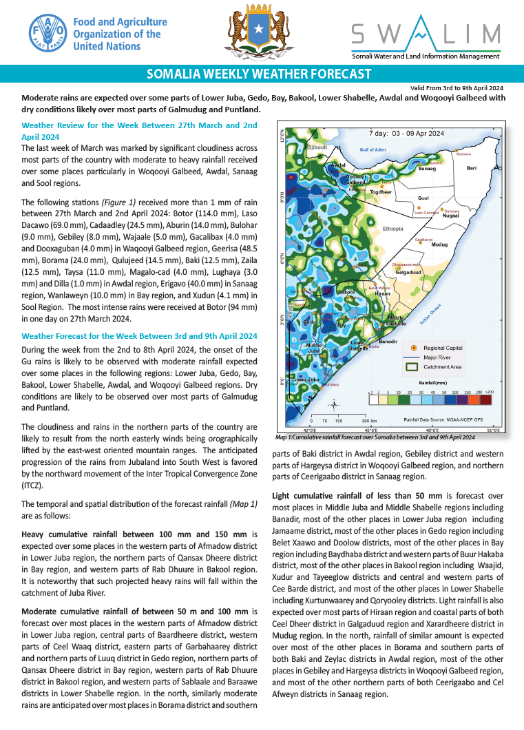
Somalia Rainfall Forecast – Issued 04 April 2024
During the week from the 2nd to 8th April 2024, the onset of the Gu rains is likely to be observed with moderate rainfall expected over some places in the following regions: Lower Juba, Gedo, Bay, Bakool, Lower Shabelle, Awdal, and Woqooyi Galbeed regions. Dry conditions are likely to be observed over most parts of Galmudug and Puntland.
The cloudiness and rains in the northern parts of the country are likely to result from the north easterly winds being orographically lifted by the east-west oriented mountain ranges. The anticipated progression of the rains from Jubaland into South West is favored by the northward movement of the Inter Tropical Convergence Zone (ITCZ).
Heavy cumulative rainfall between 100 m and 150 mm is expected over some places in the western parts of Afmadow district in Lower Juba region, the northern parts of Qansax Dheere district in Bay region, and western parts of Rab Dhuure in Bakool region. It is noteworthy that such projected heavy rains will fall within the catchment of Juba River.
Moderate cumulative rainfall between 50 mm and 100 mm is forecast over most places in the western parts of Afmadow district in Lower Juba region, central parts of Baardheere district, western parts of Ceel Waaq district, eastern parts of Garbahaarey district and northern parts of Luuq district in Gedo region, northern parts of Qansax Dheere district in Bay region, western parts of Rab Dhuure district in Bakool region, and western parts of Sablaale and Baraawe districts in Lower Shabelle region. In the north, similarly moderate rains are anticipated over most places in Borama district and southern parts of Baki district in Awdal region, Gebiley district and western parts of Hargeysa district in Woqooyi Galbeed region, and northern parts of Ceerigaabo district in Sanaag region.
Light cumulative rainfall of less than 50 mm is forecast over most places in Middle Juba and Middle Shabelle regions including Banadir, most of the other places in Lower Juba region including Jamaame district, most of the other places in Gedo region including Belet Xaawo and Doolow districts, most of the other places in Bay region including Baydhaba district and western parts of Buur Hakaba district, most of the other places in Bakool region including Waajid, Xudur and Tayeeglow districts and central and western parts of Cee Barde district, and most of the other places in Lower Shabelle including Kurtunwaarey and Qoryooley districts. Light rainfall is also expected over most parts of Hiraan region and coastal parts of both Ceel Dheer district in Galgaduud region and Xarardheere district in Mudug region. In the north, rainfall of similar amount is expected over most of the other places in Borama and southern parts of both Baki and Zeylac districts in Awdal region, most of the other places in Gebiley and Hargeysa districts in Woqooyi Galbeed region, and most of the other northern parts of both Ceerigaabo and Cel Afweyn districts in Sanaag region.
Dry conditions are likely to prevail over vast areas in the north including Bari, Sool, and Nugaal regions, Laasqoray district and central and southern parts of both Ceel Afweyn and Ceerigaabo districts in Sanaag region, Lughaye district and northern parts of both Zeylac and Baki districts in Awdal region, and Berbera district in Woqooyi Galbeed region. Dry conditions are also expected in the central parts of the country including most inland parts of Mudug region, Cabudwaaq, Cadaado, and Dhuusamareeb districts in Galgaduud region, central and northern parts of Belet Weyne district in Hiraan region, and the areas in Afgoye-Wanla Weyn districts’ boundary in Lower Shabelle.
Publication Type:
Rainfall Forecast
Publication Date:
Author:
Corporate Author:
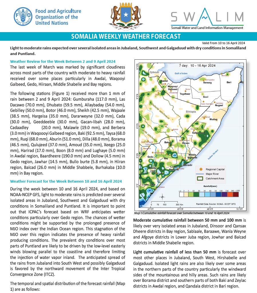
Somalia Rainfall Forecast – Issued 10 April 2024
During the week between 10 and 16 April 2024, and based on NOAA-NCEP GFS, light to moderate rains is predicted over several isolated areas in Jubaland, Southwest and Galgaduud with dry conditions in Somaliland and Puntland. It is important to point out that ICPAC’s forecast based on WRF anticipates wetter conditions particularly over Gedo region. The chances of wetter conditions might be supported by the prolonged presence of MJO index over the Indian Ocean region. This stagnation of the MJO over this region indicates the presence of heavy rainfall producing conditions. The prevalent dry conditions over most parts of Puntland are likely to be driven by the low-level easterly winds blowing parallel to the coastline and therefore limiting the injection of water vapor inland. The anticipated spread of the rains from Jubaland into South West and possibly Galgaduud is favored by the northward movement of the Inter Tropical Convergence Zone (ITCZ).
The temporal and spatial distribution of the forecast rainfall are as follows:
Heavy cumulative rainfall between 100 m and 150 mm is likely over some isolated areas over Jubaland. Based on consensus such heavy rainfall is anticipated over Kismaayo district in Lower Juba region and, Bardheere and Ceel Waaq districts in Gedo region. According to ICPAC’s forecast, the rains over Ceel Waaq district might be particularly heavy accumulating to above 150 mm. It is noteworthy that such projected heavy rains will fall within the catchment of Juba River.
Moderate cumulative rainfall between 50 mm and 100 mm is likely over very isolated areas in Jubaland, Dinsoor and Qansax Dheere districts in Bay region, Sablaale, Baraawe, Wanla Weyne and Afgoye districts in Lower Juba region, Jowhar and Balcad districts in Middle Shabelle region.
Light cumulative rainfall of less than 50 mm is forecast over most other places in Jubaland, South West, Hirshabelle and Galgaduud. Isolated light rains are also likely over some areas in the northern parts of the country particularly the windward sides of the mountainous and hilly areas. Such rains are likely over Borama district and southern parts of both Baki and Zeylac districts in Awdal region, and Qandala district in Bari region.
Based on consensus, dry conditions are likely to prevail over vast areas in Puntland and the other places in Somaliland. Specifically, such dry conditions are likely over most areas of the following regions: Mudug, Nugaal, Bari, Sool, Sanaag, Togdheer and Woqqoyi Galbeed. Some forecasts also anticipated dry conditions over some areas in Hirshabelle and Bakool region.
Temperature Forecast:
Most parts of the country particularly southern and central parts are expected to observe moderately high temperatures of between 35 ℃ and 40 ℃. However, both exceptionally elevated (above 40 ℃) and remarkably moderate temperatures (below 30 ℃) are likely in some areas. Elevated temperatures above 40 ℃ are likely over some parts of Sheikh district in Woqooyi Galbeed region and Ceel Afweyn district in Sanaag region.
Moderate temperatures of between 30 ℃ and 35 ℃ are likely some places in the north and the south and along the coastlines including the entire eastern coastline. Such temperatures are expected over most parts of Sanaag region particularly in Ceerigaabo district, most parts of southern Woqooyi Galbeed region particularly in Hargeisa district, and most parts of Borama district and southern parts of Baki district in Awdal region. In the south, these conditions are likely over Ceel Waaq district in Gedo region, Baydhaba district, eastern parts of Qansax Dheere district and northern parts of Dinsoor district in Bay region.
Temperatures less than 30 ℃ are likely over the elevated areas in the north including places in Ceerigaabo district in Sanaag region and Qandala district in Bari region.
Publication Type:
Rainfall Forecast
Publication Date:
Author:
Corporate Author:
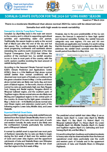
Somalia Seasonal Rainfall Outlook for Gu 2024
According to the Seasonal Climate Forecast issued by IGAD’s Climate Prediction and Applications Centre (ICPAC), there is a 55% likelihood that above normal rainfall (wetter than normal conditions) will be observed over most parts of Somalia. In the south these above normal rains are likely over Gedo, Bay, and most parts of Bakool regions. In the north, chances of above normal Gu rains are particularly high over Bari, Nugaal, Sool, Sanaag and Awdal regions, Hargeisa district in Woqooyi Galbeed region, and the southern parts of Togdheer region. Above normal rains are also likely over Mudug and Galgaduud regions in the central parts of the country, there is 40 – 50 % likelihood above normal rains over Hiraan region and extensive coastal parts of the following regions: Lower Juba, Middle Juba, and Lower Shabelle.
Publication Type:
Rainfall Outlook
Publication Date:
Author:
Corporate Author:
Somalia Rainfall Forecast – Issued 21 March 2024
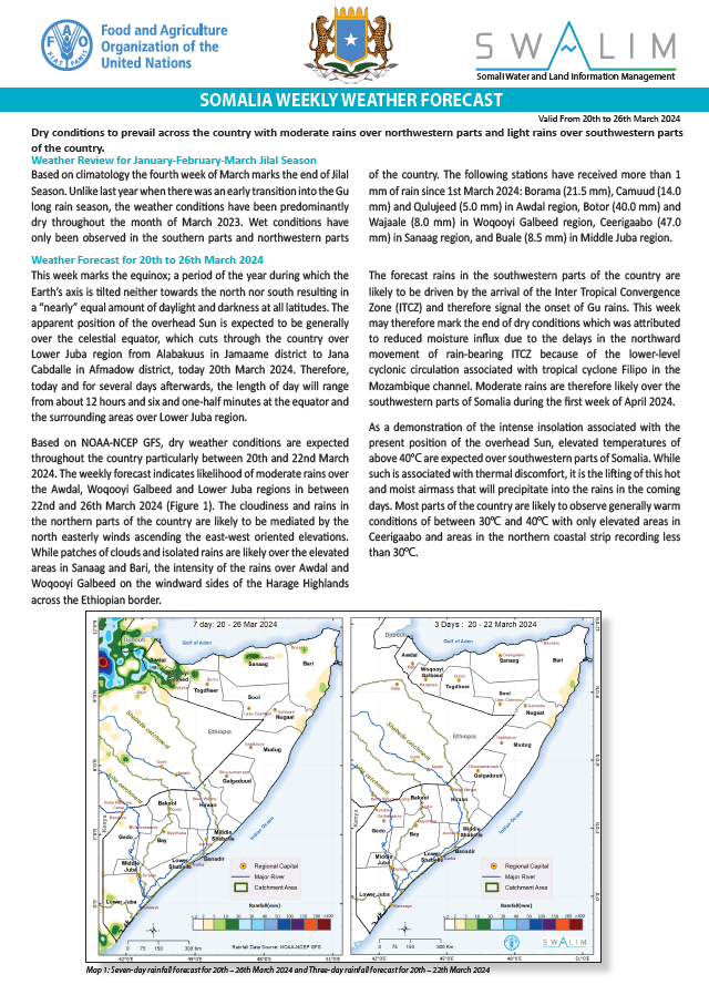
This week marks the equinox; a period of the year during which the Earth’s axis is tilted neither towards the north nor south resulting in a “nearly” equal amount of daylight and darkness at all latitudes. The apparent position of the overhead Sun is expected to be generally over the celestial equator, which cuts through the country over Lower Juba region from Alabakuus in Jamaame district to Jana Cabdalle in Afmadow district, today 20th March 2024. Therefore, today and for several days afterwards, the length of day will range from about 12 hours and six and one-half minutes at the equator and the surrounding areas over Lower Juba region.
Based on NOAA-NCEP GFS, dry weather conditions are expected throughout the country particularly between 20th and 22nd March 2024. The weekly forecast indicates likelihood of moderate rains over the Awdal, Woqooyi Galbeed and Lower Juba regions in between 22nd and 26th March 2024 (Figure 1). The cloudiness and rains in the northern parts of the country are likely to be mediated by the north easterly winds ascending the east-west oriented elevations. While patches of clouds and isolated rains are likely over the elevated areas in Sanaag and Bari, the intensity of the rains over Awdal and Woqooyi Galbeed on the windward sides of the Harage Highlands across the Ethiopian border.
The forecast rains in the southwestern parts of the country are likely to be driven by the arrival of the Inter Tropical Convergence Zone (ITCZ) and therefore signal the onset of Gu rains. This week may therefore mark the end of dry conditions which was attributed to reduced moisture influx due to the delays in the northward movement of rain-bearing ITCZ because of the lower-level cyclonic circulation associated with tropical cyclone Filipo in the Mozambique channel. Moderate rains are therefore likely over the southwestern parts of Somalia during the first week of April 2024.
As a demonstration of the intense insolation associated with the present position of the overhead Sun, elevated temperatures of above 40°C are expected over southwestern parts of Somalia. While such is associated with thermal discomfort, it is the lifting of this hot and moist airmass that will precipitate into the rains in the coming days. Most parts of the country are likely to observe generally warm conditions of between 30°C and 40°C with only elevated areas in Ceerigaabo and areas in the northern coastal strip recording less than 30°C.
Publication Type:
Rainfall Forecast
Publication Date:
Author:
Corporate Author:
Somalia Rainfall Forecast – Issued 28 March 2024
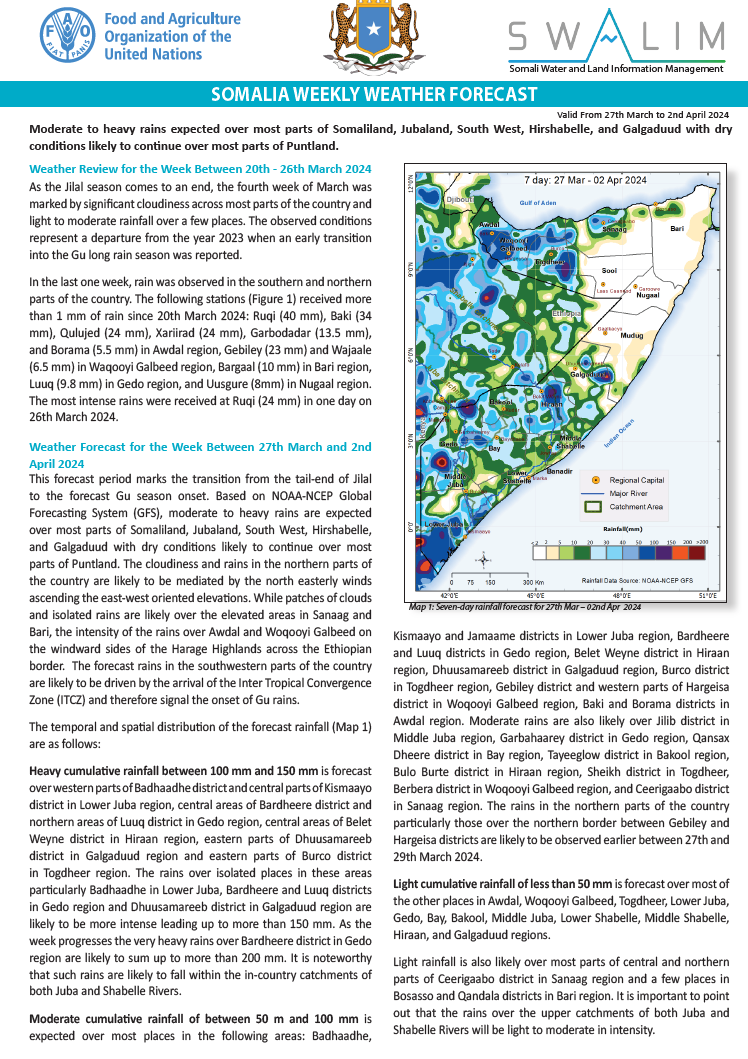
This forecast period marks the transition from the tail-end of Jilal to the forecast Gu season onset. Based on NOAA-NCEP Global Forecasting System (GFS), moderate to heavy rains are expected over most parts of Somaliland, Jubaland, South West, Hirshabelle, and Galgaduud with dry conditions likely to continue over most parts of Puntland. The cloudiness and rains in the northern parts of the country are likely to be mediated by the north easterly winds ascending the east-west oriented elevations. While patches of clouds and isolated rains are likely over the elevated areas in Sanaag and Bari, the intensity of the rains over Awdal and Woqooyi Galbeed on the windward sides of the Harage Highlands across the Ethiopian border. The forecast rains in the southwestern parts of the country are likely to be driven by the arrival of the Inter Tropical Convergence Zone (ITCZ) and therefore signal the onset of Gu rains.
The temporal and spatial distribution of the forecast rainfall (Map 1) are as follows:
Heavy cumulative rainfall between 100 mm and 150 mm is forecast over western parts of Badhaadhe district and central parts of Kismaayo district in Lower Juba region, central areas of Bardheere district and northern areas of Luuq district in Gedo region, central areas of Belet Weyne district in Hiraan region, eastern parts of Dhuusamareeb district in Galgaduud region and eastern parts of Burco district in Togdheer region. The rains over isolated places in these areas particularly Badhaadhe in Lower Juba, Bardheere and Luuq districts in Gedo region and Dhuusamareeb district in Galgaduud region are likely to be more intense leading up to more than 150 mm. As the week progresses the very heavy rains over Bardheere district in Gedo region are likely to sum up to more than 200 mm. It is noteworthy that such rains are likely to fall within the in-country catchments of both Juba and Shabelle Rivers.
Moderate cumulative rainfall of between 50 m and 100 mm is expected over most places in the following areas: Badhaadhe, Kismaayo and Jamaame districts in Lower Juba region, Bardheere and Luuq districts in Gedo region, Belet Weyne district in Hiraan region, Dhuusamareeb district in Galgaduud region, Burco district in Togdheer region, Gebiley district and western parts of Hargeisa district in Woqooyi Galbeed region, Baki and Borama districts in Awdal region. Moderate rains are also likely over Jilib district in Middle Juba region, Garbahaarey district in Gedo region, Qansax Dheere district in Bay region, Tayeeglow district in Bakool region, Bulo Burte district in Hiraan region, Sheikh district in Togdheer, Berbera district in Woqooyi Galbeed region, and Ceerigaabo district in Sanaag region. The rains in the northern parts of the country particularly those over the northern border between Gebiley and Hargeisa districts are likely to be observed earlier between 27th and 29th March 2024.
Light cumulative rainfall of less than 50 mm is forecast over most of the other places in Awdal, Woqooyi Galbeed, Togdheer, Lower Juba, Gedo, Bay, Bakool, Middle Juba, Lower Shabelle, Middle Shabelle, Hiraan, and Galgaduud regions. Light rainfall is also likely over most parts of central and northern parts of Ceerigaabo district in Sanaag region and a few places in Bosasso and Qandala districts in Bari region. It is important to point out that the rains over the upper catchments of both Juba and Shabelle Rivers will be light to moderate in intensity.
Dry conditions are likely to prevail over vast areas in Mudug region, Nugaal region, Sool region and Bari region. Dry conditions are also expected over a few places in the following areas: Ceel Afweyn and Laasqoray distrcist in Sanaag region, Cabudwaaq and Ceel Dheer districts in Galgaduud, Balcad district in Middle Shabelle, Qoryooley, Sablaale and Baraawe districts in Lower Shabelle, eastern parts of Bu’aale district in Middle Jubas, northern parts of Afmadow district in Lower Juba region.
Publication Type:
Rainfall Forecast
Publication Date:
Author:
Corporate Author:
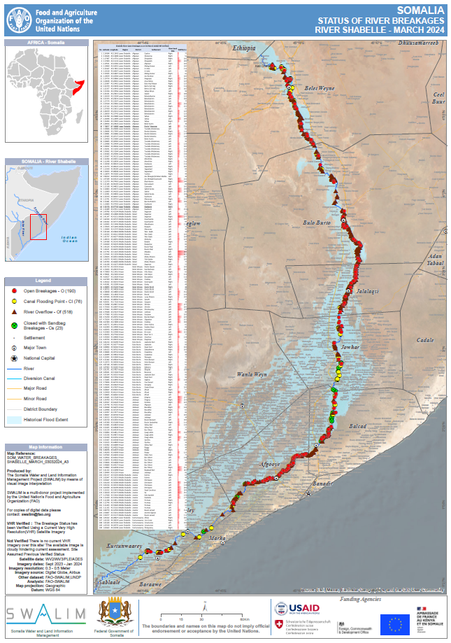
STATUS OF RIVER BREAKAGES ALONG JUBA AND SHABELLE RIVERS - ISSUED MARCH 2024
The Food and Agriculture Organization’s Somalia Water and Land Information Management (FAO SWALIM) Project, has finalized the analysis and mapping of the river breakages along the Juba and Shabelle rivers using very high resolution satellite imagery. Following the El Niño-induced widespread floods of 2023, there have been an up surge in reported open breakages.
A total of 190 Open breakage points, 76 Canal flooding points, 518 River overflow points and 23 points closed with sandbags have been identified along the Shabelle River while 109 Open breakage points, 1 Canal flooding points, 226 River overflow points and 5 points closed with sandbags have been identified along the Juba River which require immediate attention. Several other points, which are either potential or temporarily closed with sandbags, have also been identified. The forecast above average rainfall during the coming Gu season is likely to lead to high potential of flooding over the Juba and Shabelle rivers especially where open and potential points have been identified. There is therefore an immediate need to close the open points and reinforce areas where there are weak river embankments. Intervening agencies are advised to take advantage of the current dry period until the rains start and carry out temporary or long term measures to close the river breakages. This will see a reduction of riverine flooding in case of heavy rains and consequently a massive reduction in economic losses to the country.
Publication Type:
Map
Publication Date:
Author:
Corporate Author:
Review of Deyr 2023 Rainfall Performance, Jilal Status, Gu Outlook, and Implications on Livelihoods over Somalia
Several key findings have been obtained following a review of the 2023 Deyr (October-November-December) seasonal rainfall.
Heavy cumulative rainfall was observed over the south and central parts of the country with a substantial 1,152 mm being recorded in Baidoa in Bay region representing five times of the station’s Long-Term Mean (LTM). The rainfall was even much heavier in Berbera in Wooqoyi Galbeed Region where the amount was 26 times the LTM.
The Deyr rains began in early October over parts of Somaliland and central parts of Puntland spreading southwards to Gedo and Bay-Bakool regions. However, there was a sharp end to the Deyr rains particularly over Puntland and Somaliland with no single rainy day observed in Puntland in December.
There was more than 30 consecutive dry days in almost all the stations in the country between 1st October and 31st December 2023.
The observed rainfall amounts, and the length of wet spells particularly over the Juba and Shabelle River basins within the country were 100% in agreement with the forecast. The onset of Deyr rains across the country was also generally in agreement with the forecast with most of the stations realizing onset within a week of the forecast date.
Publication Type:
Rainfall Outlook
Publication Date:
Author:
Corporate Author:
Weekly Weather Forecast for SIRA II Project Districts Somaliland - Issued 01-12-2023
Weather Forecast for the Period 1st to 7th December 2023
Rainfall Forecast: Light rainfall ranging between 2 to 5 mm is expected in the northeastern parts of the project area. This encompasses the western regions of Berbera district, Banmadar and Cabdi Geeddi in the eastern regions of the Baki district, as well as Beeyo Liiban in the eastern parts of Lughaye district and Ceel Lay Heelay in the northern part of Hargeisa district. Conversely, dry conditions are expected to persist across the remaining project areas, with the likelihood of rainfall less than 2 mm.
Temperature Forecast: Mild temperatures between 20°C and 25°C are expected in the southern parts of Borama and Gebiley districts, as well as the southwest of Hargeisa district. Northern parts of Lughaye district are expected to experience relatively higher temperatures ranging from 30°C to 35°C.
For the rest of the project area, moderate temperatures between 25°C and 30°C is expected.
Publication Type:
Rainfall Forecast
Publication Date:
Author:
Corporate Author:
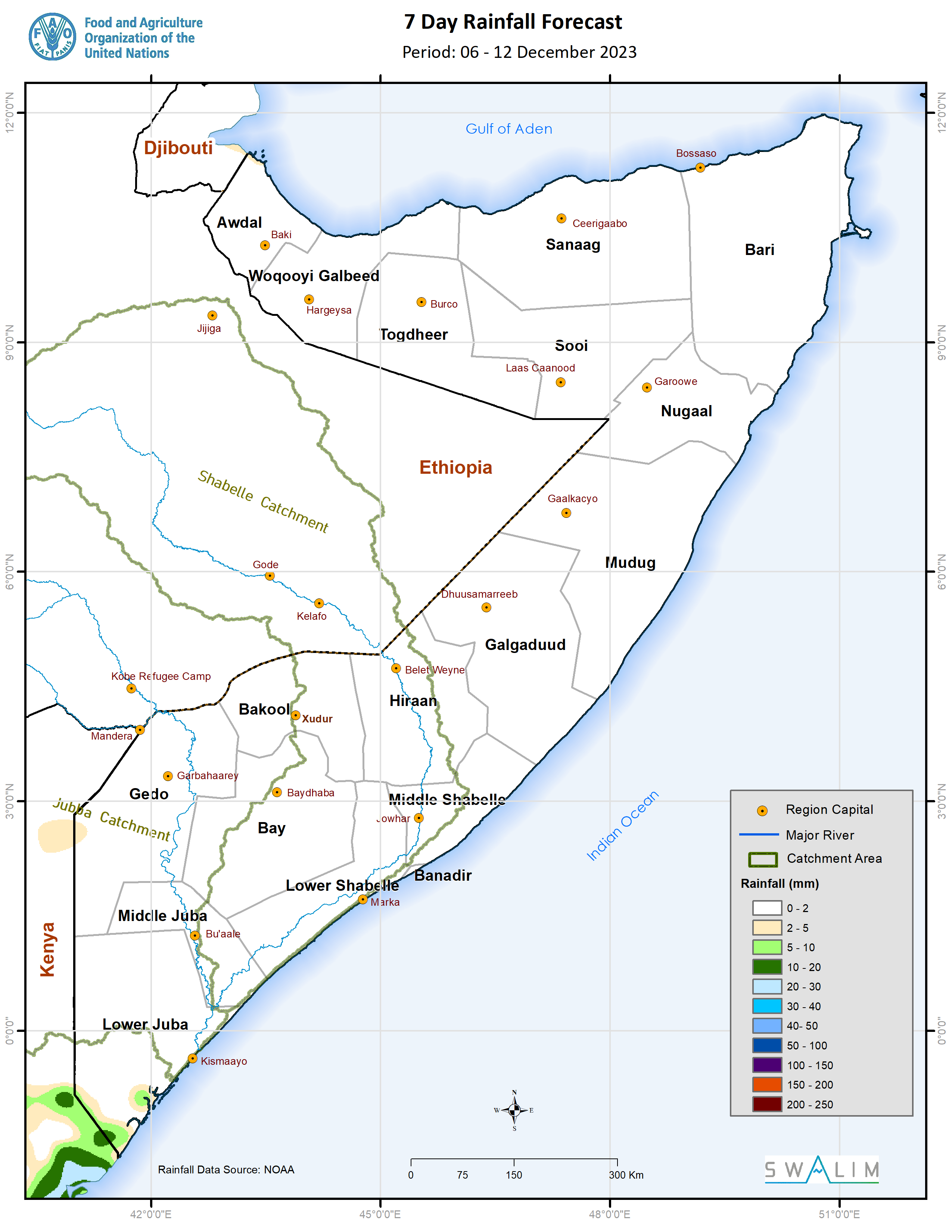
Somalia Rainfall Forecast – Issued 06 December 2023
Dry conditions: Most parts of the country are expected to remain dry during the coming week. The model predictions for the month of December indicating minimal rainfall amounts across the country and the Ethiopian highlands signals the end of the Deyr rainy season for Somalia.
Temperature Forecast: The current forecast indicates likelihood of high temperatures ranging from 30°C to 35°C over extensive areas in the south, central and northeastern parts of the country. Milder temperatures ranging between 20°C and 25°C are anticipated over some areas in the following regions: Awdal, Woqooyi Galbeed, Togdheer and Sanaag regions and inland parts of Bari region. Moderate temperatures of 25°C to 30°C are anticipated in the rest of the country.
Publication Type:
Rainfall Forecast
Publication Date:
Author:
Corporate Author:
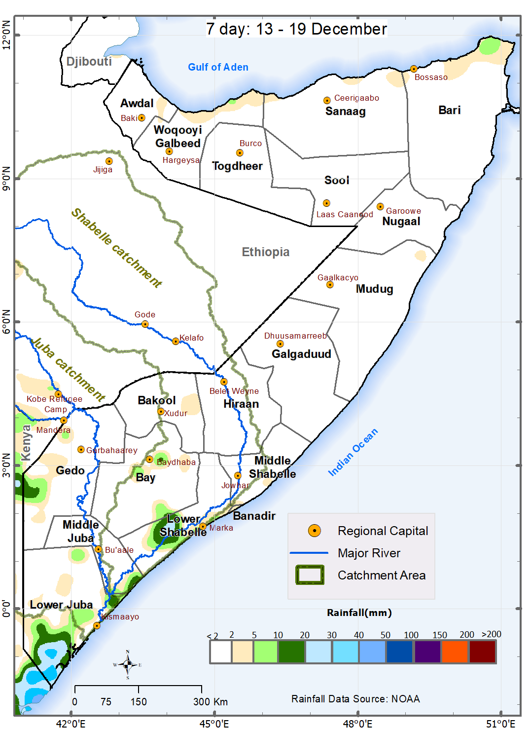
Somalia Rainfall Forecast – Issued 13 December 2023
Light rainfall of below 50 mm is forecast over some areas in the southern parts of the country in the coming week. These light rains are expected in the earlier part of the forecast week (13th – 15th December) over Badhaadhe, Kismayo and Jamaame districts in Lower Juba region, Ceel Waaq and Belet Xaawo districts in the Gedo region. Other areas expected to receive the light rains are the coastal areas of Jilib district in Middle Juba region, Marca and Kurtunwaarey districts, areas in the Sablaale, Qoryooley, and Barawe districts in Lower Shabelle region, and Baidoa in Bay region. Although moderate in cumulative amounts, the rains over the Lower Juba region are likely to be spread out across the entire week and will therefore be less intense. Moderate rains above 50 mm may be observed in some areas along the southern coastal strip whenever the monsoonal winds blowing parallel to the coastline are accentuated by any elevated East-West oriented terrain. As these monsoonal winds blow southwards across the Gulf, there are also chances of trace amounts of rains over the northern coastal strip including Caluula and Qandala districts in Bari region and Berbera districts in Woqooyi Galbeed region.
Dry conditions – The rest of the country is expected to remain dry during the coming week. The model predictions of minimal rainfall amount across the country and the Ethiopian highlands in the month of December signals the end of the Deyr rainy season for Somalia.
Publication Type:
Rainfall Forecast
Publication Date:
Author:
Corporate Author:
Pages
 RSS feed [compliant with the Agris AP] |
  Agris AP XML