Library Catalog
Latest Documents and Publications listed. Use search terms in the box below to find what you need
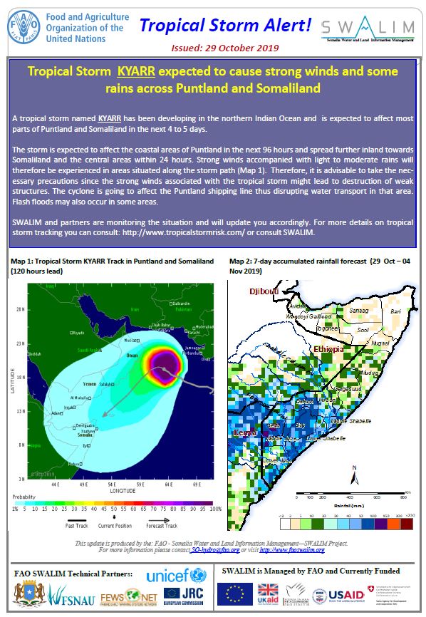
Tropical Storm Alert - Issued 29 October 2019
Tropical Storm KYARR expected to cause strong winds and some rains across Puntland and Somaliland
A tropical storm named KYARR has been developing in the northern Indian Ocean and is expected to affect most parts of Puntland and Somaliland in the next 4 to 5 days.
The storm is expected to affect the coastal areas of Puntland in the next 96 hours and spread further inland towards Somaliland and the central areas within 24 hours. Strong winds accompanied with light to moderate rains will therefore be experienced in areas situated along the storm path. Therefore, it is advisable to take the necessary precautions since the strong winds associated with the tropical storm might lead to destruction of weak structures. The cyclone is going to affect the Puntland shipping line thus disrupting water transport in that area. Flash floods may also occur in some areas.
Publication Type:
Flood Alert
Publication Date:
Author:
Corporate Author:
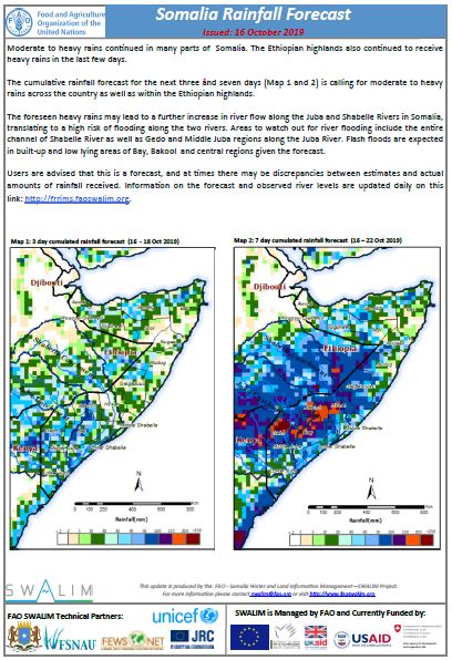
Somalia Rainfall Forecast: Issued 16-10-2019
Moderate to heavy rains continued in many parts of Somalia. The Ethiopian highlands also continued to receive heavy rains in the last few days.
The cumulative rainfall forecast for the next three and seven days is calling for moderate to heavy rains across the country as well as within the Ethiopian highlands.
The foreseen heavy rains may lead to a further increase in river flow along the Juba and Shabelle Rivers in Somalia, translating to a high risk of flooding along the two rivers. Areas to watch out for river flooding include the entire channel of Shabelle River as well as Gedo and Middle Juba regions along the Juba River. Flash floods are expected in built-up and low lying areas of Bay, Bakool and central regions given the forecast.
Publication Type:
Publication Date:
Author:
Corporate Author:
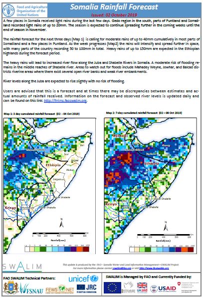
Somalia Rainfall Forecast: Issued 02-10-2019
A few places in Somalia received light rains during the last few days. Gedo region in the south, parts of Puntland and Somaliland recorded light rains of up to 20mm. The season is expected to continue spreading further in the coming weeks until the end of season in November.
The rainfall forecast for the next three days is calling for moderate rains of up to 40mm cumulatively in most parts of Somaliland and a few places in Puntland. As the week progresses the rains will intensify and spread further in space, with many parts of the country recording 50 to 100mm in total. Heavy rains of up to 150mm are expected in the Ethiopian highlands during the forecast period.
The heavy rains will lead to increased river flow along the Juba and Shabelle Rivers in Somalia. A moderate risk of flooding remains in the middle reaches of Shabelle river. Areas to watch out for floods include Mahadey Weyne, Jowhar, and Balcad districts riverine areas where there exist several open river banks and weak river embankments.
River levels along the Juba are expected to rise slightly with no risk of flooding.
Publication Type:
Rainfall Forecast
Publication Date:
Author:
Corporate Author:
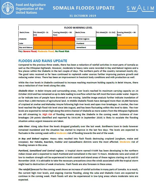
Somalia Flood Update - Issued 31 October 2019
Compared to the previous three weeks, there has been a reduction of rainfall activities in most parts of Somalia as well as the Ethiopian highlands. However, moderate to heavy rains were recorded in Bay and Bakool regions and a few places within the Shabelle in the last couple of days. The northern parts of the country remained mostly dry. The good rains received so far have continued to replenish water sources further improving pasture growth and reducing water stress. There has been an improvement in livestock body conditions and milk production as well.
While the river levels in Shabelle continued to increase reaching maximum holding capacity in Belet Weyne, there was a reduction of river levels along the Juba.
Shabelle River: In Belet Weyne and surrounding areas, river levels reached its maximum carrying capacity on 24 October 2019 and has remained so up to date leading to overflow which has left most the town under water. Reports so far indicate tens of people have drowned or are missing. Satellite image analysis further indicate inundation of more than 2,000 Hectares of agricultural land. In Middle Shabelle floods have damaged more than 10,000 hectares of cropland at Jowhar and Mahaday Weyne following high river levels and open river breakages. In Jowhar, the river level reached the high flood risk level since late August, and has been fluctuating within this level to date. The river levels are expected to remain high along the entire channel of Shabelle as more waters from the Ethiopian highlands are still streaming in. High risk of flooding remains along the Shabelle in the coming week. Existence of river breakages (39 points identified and reported by SWALIM in September 2019) is likely to escalate the flooding situation unless urgent measures are taken.
Juba River: Along Juba River the levels dropped gradually over the last week. Bardheere town in Gedo however remained inundated and the situation has started to improve in the last few days. The levels are expected to fluctuate in the coming week with a Moderate risk of flooding towards the end of the week.
In Bay and Bakool regions: Heavy rains resulted into flash floods destroying cropland (sorghum, maize and cowpeas). Bur Hakaba, Baardale, Huddur and Qansadheere districts were the most affected. Moderate risk of flooding remain in this area.
Puntland, Somaliland and Central regions: A tropical storm named KYARR has been developing in the northern Indian Ocean and is expected to reach Puntland and Somaliland in the next 72 Hours. Moderate rains and winds of low to medium strength will be experienced in both coastal and inland areas of these regions starting on 02 and 03 November 2019. It is advisable to take the necessary precautions since the winds associated with the tropical storm might lead to destruction of weak structures. Flash floods are also foreseen in these areas.
The rainfall forecast for the coming week shows an increase of rainfall activities in many parts of Somalia. As a result, the current high river levels, and ongoing riverine flooding, along the Juba and Shabelle rivers are expected to continue in the coming week. Flash floods will also be experienced in low-lying areas where moderate rains are expected.
Publication Type:
Publication Date:
Author:
Corporate Author:
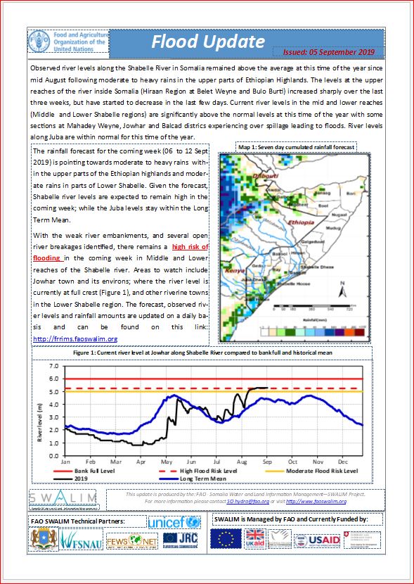
Flood Update for Middle and Lower Shabelle - Issued 05-09-2019
Observed river levels along the Shabelle River in Somalia remained above the average at this time of the year since mid August following moderate to heavy rains in the upper parts of Ethiopian Highlands. The levels at the upper reaches of the river inside Somalia (Hiraan Region at Belet Weyne and Bulo Burti) increased sharply over the last three weeks, but have started to decrease in the last few days. Current river levels in the mid and lower reaches (Middle and Lower Shabelle regions) are significantly above the normal levels at this time of the year with some sections at Mahadey Weyne, Jowhar and Balcad districs experiencing over spillage leading to floods. River levels along Juba are within normal for this time of the year.
Publication Type:
Flood Alert
Publication Date:
Author:
Corporate Author:
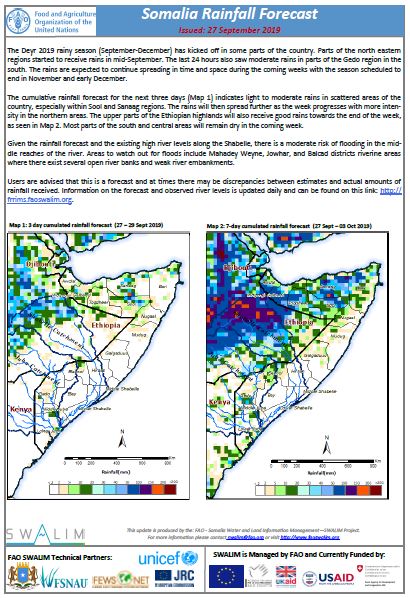
Somalia Rainfall Forecast: Issued 27-09-2019
The Deyr 2019 rainy season (September-December) has kicked off in some parts of the country. Parts of the north eastern regions started to receive rains in mid-September. The last 24 hours also saw moderate rains in parts of the Gedo region in the south. The rains are expected to continue spreading in time and space during the coming weeks with the season scheduled to end in November and early December.
The cumulative rainfall forecast for the next three days indicates light to moderate rains in scattered areas of the country, especially within Sool and Sanaag regions. The rains will then spread further as the week progresses with more intensity in the northern areas. The upper parts of the Ethiopian highlands will also receive good rains towards the end of the week. Most parts of the south and central areas will remain dry in the coming week.
Given the rainfall forecast and the existing high river levels along the Shabelle, there is a moderate risk of flooding in the middle reaches of the river. Areas to watch out for floods include Mahadey Weyne, Jowhar, and Balcad districts riverine areas where there exist several open river banks and weak river embankments.
Publication Type:
Rainfall Forecast
Publication Date:
Author:
Corporate Author:
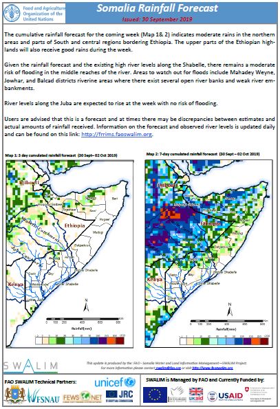
Somalia Rainfall Forecast: Issued 30-09-2019
The cumulative rainfall forecast for the coming week indicates moderate rains in the northern areas and parts of South and central regions bordering Ethiopia. The upper parts of the Ethiopian highlands will also receive good rains during the week.
Given the rainfall forecast and the existing high river levels along the Shabelle, there remains a moderate risk of flooding in the middle reaches of the river. Areas to watch out for floods include Mahadey Weyne, Jowhar, and Balcad districts riverine areas where there exist several open river banks and weak river embankments.
River levels along the Juba are expected to rise at the week with no risk of flooding.
Publication Type:
Rainfall Forecast
Publication Date:
Author:
Corporate Author:
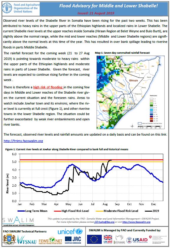
Flood Advisory for Middle and Lower Shabelle - Issued 21-08-2019
Observed river levels of the Shabelle River in Somalia have been rising for the past two weeks. This has been attributed to heavy rains in the upper parts of the Ethiopian highlands and localized rains in Lower Shabelle. The current Shabelle river levels at the upper reaches inside Somalia (Hiraan Region at Belet Weyne and Bulo Burti), are slightly above the normal range, while the mid and lower reaches (Middle and Lower Shabelle regions) are significantly above the normal levels at this time of the year. This has resulted in over bank spillage leading to riverine floods in parts Middle Shabelle.
The ongoing assessment of river breakages along the Shabelle River using Very High Resolution (VHR) Satellite images, has identified several open points along the River, these open points continue to pose a threat of flooding and need immediate closure before the coming Deyr rainy season which is expected in October 2019. The river breakage analysis is being finalized and will be shared once complete.
There is a high risk of flooding in the mid and lower sections of the Shabelle river especially in areas with open river banks. The Food and Agriculture Organization’s Somalia Water and Land Information Management (FAO SWALIM) is pleased to share with you a Flood Advisory for Middle and Lower Shabelle.
Publication Type:
Flood Alert
Publication Date:
Author:
Corporate Author:
Somalia Rainfall Outlook for Deyr 2019
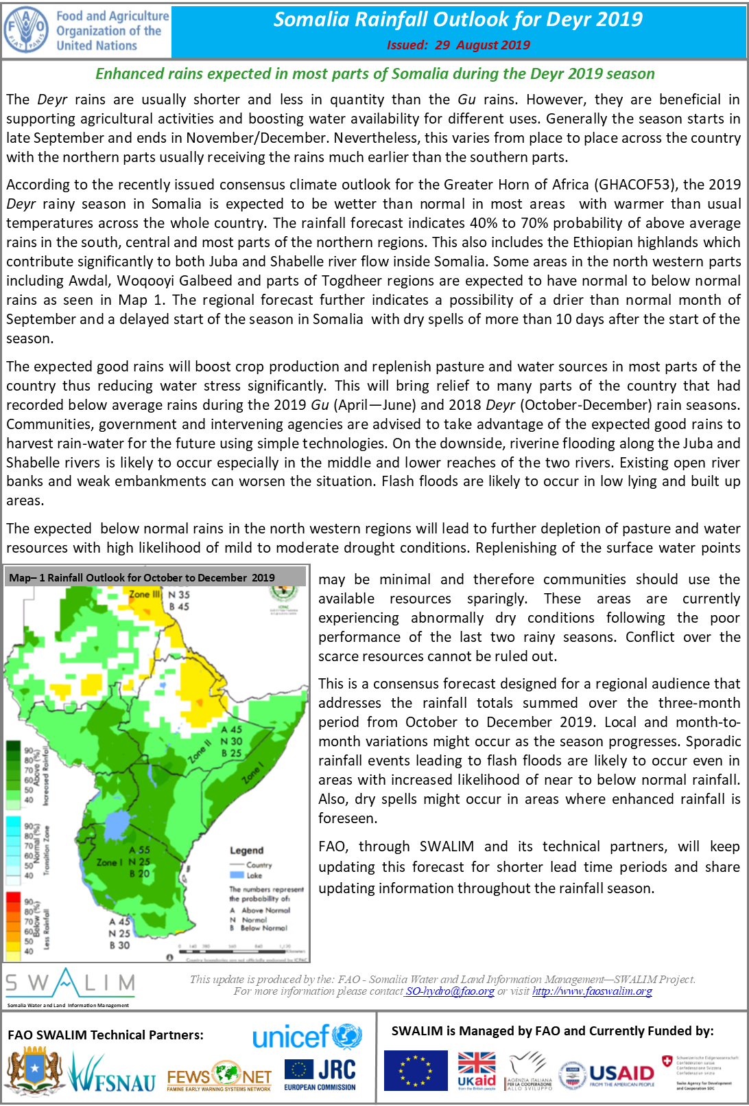
The Deyr rains are usually shorter and less in quantity than the Gu rains. However, they are beneficial in supporting agricultural activities and boosting water availability for different uses. Generally the season starts in late September and ends in November/December. Nevertheless, this varies from place to place across the country with the northern parts usually receiving the rains much earlier than the southern parts.
According to the recently issued consensus climate outlook for the Greater Horn of Africa (GHACOF53), the 2019 Deyr rainy season in Somalia is expected to be wetter than normal in most areas with warmer than usual temperatures across the whole country. The rainfall forecast indicates 45% to 55% probability of above average rains in the south, central and most parts of the northern regions. This also includes the Ethiopian highlands which contribute significantly to both Juba and Shabelle river flow inside Somalia. Some areas in the north western parts including Awdal, Woqooyi Galbeed and parts of Togdheer regions are expected to have normal to below normal rains as seen in Map 1. The regional forecast further indicates a possibility of a drier than normal month of September and a delayed start of the season in Somalia with dry spells of more than 10 days after the start of the season.
The expected good rains will boost crop production and replenish pasture and water sources in most parts of the country thus reducing water stress significantly. This will bring relief to many parts of the country that had recorded below average rains during the 2019 Gu (April—June) and 2018 Deyr (October-December) rain seasons. Communities, government and intervening agencies are advised to take advantage of the expected good rains to harvest rain-water for the future using simple technologies. On the downside, riverine flooding along the Juba and Shabelle rivers is likely to occur especially in the middle and lower reaches of the two rivers. Existing open river banks and weak embankments can worsen the situation. Flash floods are likely to occur in low lying and built up areas.
The expected below normal rains in the north western regions will lead to further depletion of pasture and water resources with high likelihood of mild to moderate drought conditions. Replenishing of the surface water points may be minimal and therefore communities should use the available resources sparingly. These areas are currently experiencing abnormally dry conditions following the poor performance of the last two rainy seasons. Conflict over the scarce resources cannot be ruled out.
This is a consensus forecast designed for a regional audience that addresses the rainfall totals summed over the three‐month period from October to December 2019. Local and month-to-month variations might occur as the season progresses. Sporadic rainfall events leading to flash floods are likely to occur even in areas with increased likelihood of near to below normal rainfall. Also, dry spells might occur in areas where enhanced rainfall is foreseen.
FAO, through SWALIM and its technical partners, will keep updating this forecast for shorter lead time periods and share updating information throughout the rainfall season.
Publication Type:
Rainfall Outlook
Publication Date:
Author:
Corporate Author:
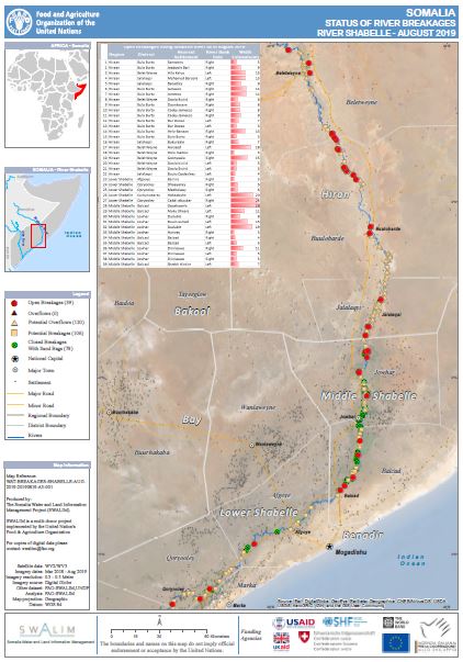
Status of River Breakages Along Juba and Shabelle Rivers - Issued Aug 2019
The Food and Agriculture Organization’s Somalia Water and Land Information Management (FAO SWALIM) Project, has finalised the analysis and mapping of the river breakages along the Juba and Shabelle rivers using very high resolution satellite imagery.
Breakages identified in the map have been classified into six different categories; Open, Overflow, Potential Overflows, Potential breakages, Closed with sandbags and Closed. A legend/Key for further explanation of the different types of breakages is provided here
A total of 84 Open points have been identified, 39 on the Shabelle River and 45 on the Juba River which require immediate attention. Due to the low Gu rainfall, no new overflow points were identified as the river levels did not reach overflow threshold. However some overflows could be expected when river level rises above the normal rate. Several other points, which are either potential or temporarily closed with sandbags, have also been identified.
The ongoing rains in the upper parts of the Ethiopian highlands have resulted to increased river levels in the lower reaches of the Shabelle River, causing floods in some areas of Jowhar and Balcad districts. With the rainfall outlook indicating above normal rains during the October - December Dery rain season, river levels are expected to increase with a likelihood of flooding especially where open and potential points have been identified. There is therefore an immediate need to close the open points and reinforce areas where there are weak river embankments. Temporary measures can be taken before the season begins.
SWALIM is pleased to share with you maps and tables of the status of river breakages along the two rivers. Hardcopies can be obtained from FAO SWALIM offices.
It is worth noting that the methodology is biased towards Remote Sensing (RS) interpretation with only limited “ground truthing” due to access constraints. Open breakages and overflows might have been omitted or classified as potential in some cases where satellite images were not available or may not have been very clear due to heavy cloud cover and dense vegetation cover.
Publication Type:
Publication Date:
Author:
Corporate Author:
Pages
 RSS feed [compliant with the Agris AP] |
  Agris AP XML