Library Catalog
Latest Documents and Publications listed. Use search terms in the box below to find what you need
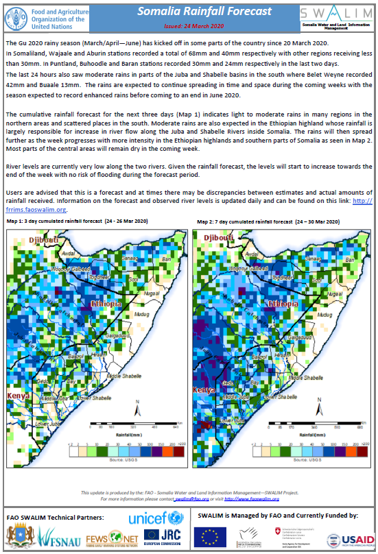
Somalia Rainfall Forecast - Issued 24 March 2020
The Gu 2020 rainy season (March/April—June) has kicked off in some parts of the country since 20 March 2020.
In Somaliland, Wajaale and Aburin stations recorded a total of 68mm and 40mm respectively with other regions receiving less than 30mm. In Puntland, Buhoodle and Baran stations recorded 30mm and 24mm respectively in the last two days.
The last 24 hours also saw moderate rains in parts of the Juba and Shabelle basins in the south where Belet Weyne recorded 42mm and Buaale 13mm. The rains are expected to continue spreading in time and space during the coming weeks with the season expected to record enhanced rains before coming to an end in June 2020.
The cumulative rainfall forecast for the next three days indicates light to moderate rains in many regions in the northern areas and scattered places in the south. Moderate rains are also expected in the Ethiopian highland whose rainfall is largely responsible for increase in river flow along the Juba and Shabelle Rivers inside Somalia. The rains will then spread further as the week progresses with more intensity in the Ethiopian highlands and southern parts of Somalia. Most parts of the central areas will remain dry in the coming week.
River levels are currently very low along the two rivers. Given the rainfall forecast, the levels will start to increase towards the end of the week with no risk of flooding during the forecast period.
Publication Type:
Rainfall Forecast
Publication Date:
Author:
Corporate Author:
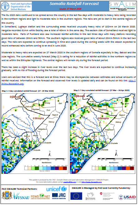
Somalia Rainfall Forecast - Issued 27 March 2020
The Gu 2020 rains continued to be spread across the country in the last few days with moderate to heavy rains being recorded in the northern regions and light to moderate rains in the southern regions. The rains are yet to start in the central regions of the country.
In Somaliland, Lughaye station and the surrounding areas received unusually heavy rains of 102mm on 26 March 2020. Hargeisa recorded 61mm while Gebiley saw a total of 40mm in the same day. The eastern side of Somaliland received light to moderate rains. Parts of Puntland also saw increased rainfall activities in the last three days with many stations recording good rains of between 20mm and 50mm. The southern regions also received good rains of about 20mm-50mm in the last two days. The rains are expected to continue spreading in time and space during the coming weeks with the season expected to record enhanced rains before coming to an end in June 2020.
Moderate to heavy rains are expected on 27 March 2020 in the southern regions of Somalia especially in Bay, Bakool and the Juba regions. The cumulative weekly forecast is calling for a reduction of rainfall activities in the northern regions as well as within the Ethiopian highlands. The central regions will remain dry during the forecast period.
There has been a slight increase in river levels over the last two days. The river levels are expected to continue increasing gradually with no risk of flooding during the forecast period.
Publication Type:
Rainfall Forecast
Publication Date:
Author:
Corporate Author:
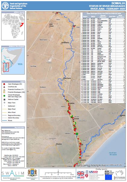
Status of River Breakages Along Juba and Shabelle Rivers - Issued March 2020
The Food and Agriculture Organization’s Somalia Water and Land Information Management (FAO SWALIM) Project, has finalized the analysis and mapping of the river breakages along the Juba and Shabelle rivers using very high resolution satellite imagery. Breakages identified in the map have been classified into five different categories; Open, Overflow, Potential Overflows, Potential breakages and Closed with sandbags. A legend/Key for further explanation of the different types of breakages is provided here.
The heavy rains during the Deyr 2019 rainy season led to increased flow causing overflow and riverbank breakages in sections of the two rivers. Henceforth, there was an increase of the open points from the previous assessment of August 2019.
A total of 152 Open points have been identified, 100 on the Shabelle River and 52 on the Juba River which require immediate attention. Several other points, which are either potential or temporarily closed with sandbags, have also been identified.
The Gu 2020 rainfall outlook is calling for enhanced rains within the Juba and Shabelle Rivers as well as the Ethiopian highlands. Consequently, river levels are expected to increase with a high likelihood of flooding especially where open and potential points have been identified.
There is therefore an immediate need to close the open points and reinforce areas where there are weak river embankments. Intervening agencies are advised to take advantage of the current dry period until the rains start and carry out temporary or long term measures to close the river breakages. This will see a reduction of riverine flooding in case of heavy rains and consequently a massive reduction in economic losses to the country.
SWALIM is pleased to share with you maps and tables of the status of river breakages along the two rivers. Hardcopies can be obtained from FAO SWALIM offices.
It is worth noting that the methodology is biased towards Remote Sensing (RS) interpretation with only limited “ground truthing” due to constraints in accessing the areas. Open breakages and overflows might have been omitted or classified as potential in some cases where satellite images were not available or may not have been very clear due to heavy cloud cover and dense vegetation cover.
Publication Type:
Map
Publication Date:
Author:
Corporate Author:
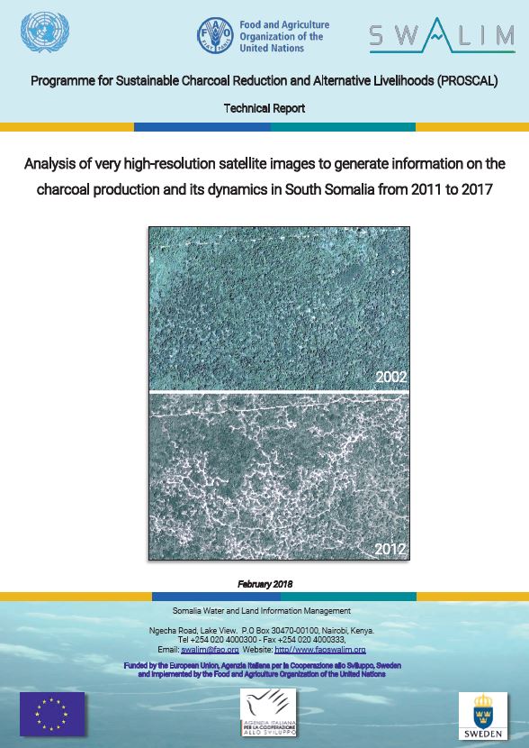
Update of analysis of very high-resolution satellite images to generate information on the charcoal production and its dynamics in South Somalia from 2011 to 2019
Charcoal is made by burning wood in a low-oxygen environment. According to FAO statistics, Africa accounts for 55% of the global charcoal production (FAO, 2014). However, these charcoal production estimates are often inaccurate when disaggregated at the national level. For many African countries, detailed information is lacking partly due to the informality and clandestine nature of production sector and the scattered production by rural population (Mwampamba et al, 2013). Estimates are consequently based on analytical and projection models that use woodfuel information of countries in similar socioeconomic and geographical situations, or by multiplying the country population by a per capita estimate
Publication Type:
Technical report
Publication Date:
Author:
Corporate Author:
Somalia Rainfall Outlook for Gu 2020
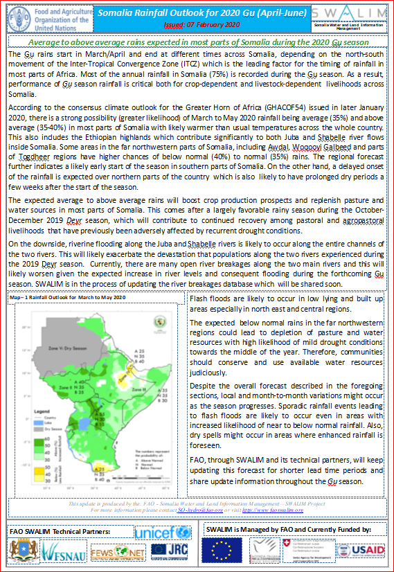
The Gu rains start in March/April and end at different times across Somalia, depending on the north-south movement of the Inter-Tropical Convergence Zone (ITCZ) which is the leading factor for the timing of rainfall in most parts of Africa. Most of the annual rainfall in Somalia (75%) is recorded during the Gu season. As a result, performance of Gu season rainfall is critical both for crop-dependent and livestock-dependent livelihoods across Somalia.
According to the consensus climate outlook for the Greater Horn of Africa (GHACOF54) issued in later January 2020, there is a strong possibility (greater likelihood) of March to May 2020 rainfall being average (35%) and above average (35-40%) in most parts of Somalia with likely warmer than usual temperatures across the whole country. This also includes the Ethiopian highlands which contribute significantly to both Juba and Shabelle river flows inside Somalia. Some areas in the far northwestern parts of Somalia, including Awdal, Woqooyi Galbeed and parts of Togdheer regions have higher chances of below normal (40%) to normal (35%) rains. The regional forecast further indicates a likely early start of the season in southern parts of Somalia. On the other hand, a delayed onset of the rainfall is expected over northern parts of the country which is also likely to have prolonged dry periods a few weeks after the start of the season.
The expected average to above average rains will boost crop production prospects and replenish pasture and water sources in most parts of Somalia. This comes after a largely favorable rainy season during the October-December 2019 Deyr season, which will contribute to continued recovery among pastoral and agropastoral livelihoods that have previously been adversely affected by recurrent drought conditions.
On the downside, riverine flooding along the Juba and Shabelle rivers is likely to occur along the entire channels of the two rivers. This will likely exacerbate the devastation that populations along the two rivers experienced during the 2019 Deyr season. Currently, there are many open river breakages along the two main rivers and this will likely worsen given the expected increase in river levels and consequent flooding during the forthcoming Gu season. SWALIM is in the process of updating the river breakages database which will be shared soon.
Flash floods are likely to occur in low lying and built up areas especially in north east and central regions.
The expected below normal rains in the far northwestern regions could lead to depletion of pasture and water resources with high likelihood of mild drought conditions towards the middle of the year. Therefore, communities should conserve and use available water resources judiciously.
Despite the overall forecast described in the foregoing sections, local and month-to-month variations might occur as the season progresses. Sporadic rainfall events leading to flash floods are likely to occur even in areas with increased likelihood of near to below normal rainfall. Also, dry spells might occur in areas where enhanced rainfall is foreseen.
FAO, through SWALIM and its technical partners, will keep updating this forecast for shorter lead time periods and share update information throughout the Gu season
Publication Type:
Rainfall Outlook
Publication Date:
Author:
Corporate Author:
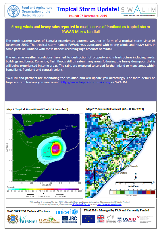
Somalia Tropical Storm Alert - Issued 07 December 2019
Strong winds and heavy rains reported in coastal areas of Puntland as tropical storm PAWAN Makes Landfall
The north eastern parts of Somalia experienced extreme weather in form of a tropical storm since 06 December 2019. The tropical storm named PAWAN was associated with strong winds and heavy rains in some parts of Puntland with most stations recording high amounts of rainfall.
The extreme weather conditions have led to destruction of property and infrastructure including roads, buildings and boats. Currently, flash floods still threaten many areas following the heavy downpour that is still being experienced in some areas. The rains are expected to spread further inland to many areas within Somaliland, Puntland and central regions.
SWALIM and partners are monitoring the situation and will update you accordingly. For more details on tropical storm tracking you can consult: http://www.tropicalstormrisk.com/ or SWALIM.
Publication Type:
Storm Alert
Publication Date:
Author:
Corporate Author:
Somalia Rainfall Forecast: Issued 09 December 2019
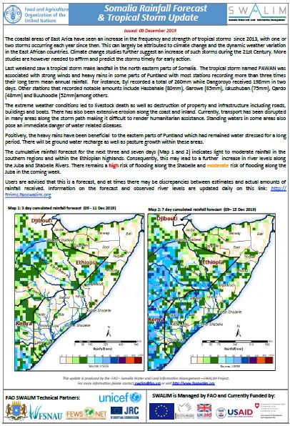
The coastal areas of East Arica have seen an increase in the frequency and strength of tropical storms since 2013, with one or two storms occurring each year since then. This can largely be attributed to climate change and the dynamic weather variation in the East African countries. Climate change studies further suggest an increase of such storms during the 21st Century. More studies are however needed to affirm and predict the storms timely for early action.
Last weekend saw a tropical storm make landfall in the north eastern parts of Somalia. The tropical storm named PAWAN was associated with strong winds and heavy rains in some parts of Puntland with most stations recording more than three times their long term mean annual rainfall. For instance, Eyl recorded a total of 260mm while Dangoroyo received 198mm in two days. Other stations that recorded notable amounts include Hasbahale (80mm), Garowe (85mm), Iskushuban (75mm), Qardo (48mm) and Buuhoodle (52mm)among others.
The extreme weather conditions led to livestock death as well as destruction of property and infrastructure including roads, buildings and boats. There has also been extensive erosion along the coast and inland. Currently, transport has been disrupted in many areas along the storm path making it difficult to render humanitarian assistance. Standing waters in some areas also pose an immediate danger of water related diseases.
Positively, the heavy rains have been beneficial to the eastern parts of Puntland which had remained water stressed for a long period. There will be ground water recharge as well as pasture growth within these areas.
The cumulative rainfall forecast for the next three and seven days (Map 1 and 2) indicates light to moderate rainfall in the southern regions and within the Ethiopian highlands. Consequently, this may lead to a further increase in river levels along the Juba and Shabelle Rivers. There remains a high risk of flooding along the Shabelle and moderate risk of flooding along the Juba in the coming week.
Publication Type:
Rainfall Forecast
Publication Date:
Author:
Corporate Author:
Somalia Rainfall Forecast: Issued 03 December 2019
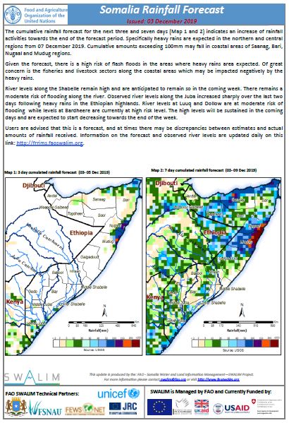
The cumulative rainfall forecast for the next three and seven days (Map 1 and 2) indicates an increase of rainfall activities towards the end of the forecast period. Specifically heavy rains are expected in the northern and central regions from 07 December 2019. Cumulative amounts exceeding 100mm may fall in coastal areas of Saanag, Bari, Nugaal and Mudug regions.
Given the forecast, there is a high risk of flash floods in the areas where heavy rains area expected. Of great concern is the fisheries and livestock sectors along the coastal areas which may be impacted negatively by the heavy rains.
River levels along the Shabelle remain high and are anticipated to remain so in the coming week. There remains a moderate risk of flooding along the river. Observed river levels along the Juba increased sharply over the last two days following heavy rains in the Ethiopian highlands. River levels at Luuq and Dollow are at moderate risk of flooding while levels at Bardheere are currently at high risk level. The high levels will be sustained in the coming days and are expected to start decreasing towards the end of the week.
Publication Type:
Rainfall Forecast
Publication Date:
Author:
Corporate Author:
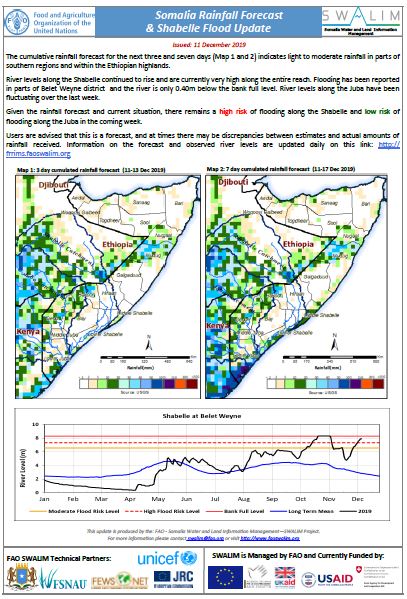
Somalia Rainfall Forecast: Issued 11 December 2019
The cumulative rainfall forecast for the next three and seven days indicates light to moderate rainfall in parts of southern regions and within the Ethiopian highlands.
River levels along the Shabelle continued to rise and are currently very high along the entire reach. Flooding has been reported in parts of Belet Weyne district and the river is only 0.40m below the bank full level. River levels along the Juba have been fluctuating over the last week.
Given the rainfall forecast and current situation, there remains a high risk of flooding along the Shabelle and low risk of flooding along the Juba in the coming week.
Publication Type:
Rainfall Forecast
Publication Date:
Author:
Corporate Author:
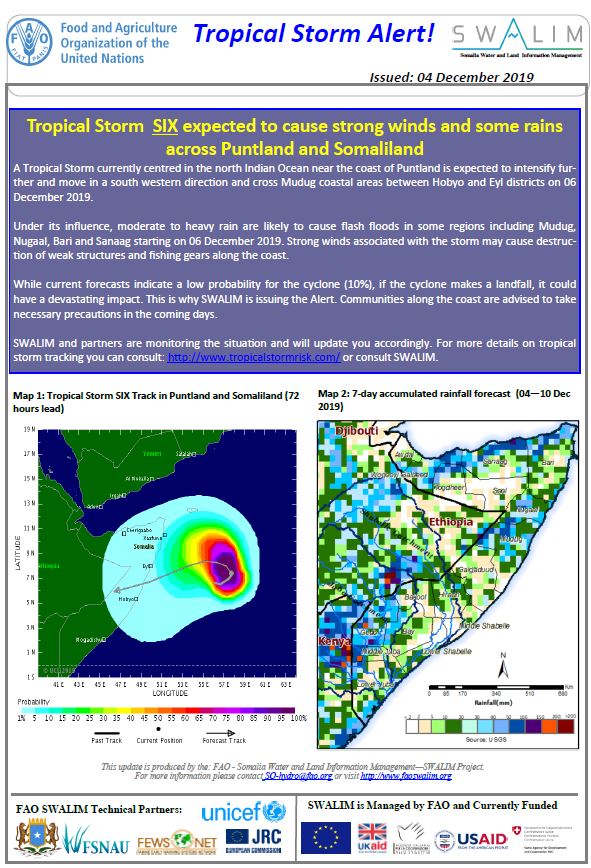
Somalia Tropical Storm Alert - Issued 04 December 2019
Tropical Storm SIX expected to cause strong winds and some rains across Puntland and Somaliland
A Tropical Storm currently centred in the north Indian Ocean near the coast of Puntland is expected to intensify further and move in a south western direction and cross Mudug coastal areas between Hobyo and Eyl districts on 06 December 2019.
Under its influence, moderate to heavy rain are likely to cause flash floods in some regions including Mudug, Nugaal, Bari and Sanaag starting on 06 December 2019. Strong winds associated with the storm may cause destruction of weak structures and fishing gears along the coast.
While current forecasts indicate a low probability for the cyclone (10%), if the cyclone makes a landfall, it could have a devastating impact. This is why SWALIM is issuing the Alert. Communities along the coast are advised to take necessary precautions in the coming days.
SWALIM and partners are monitoring the situation and will update you accordingly. For more details on tropical storm tracking you can consult: http://www.tropicalstormrisk.com/ or consult SWALIM.
Publication Type:
Storm Alert
Publication Date:
Author:
Corporate Author:
Pages
 RSS feed [compliant with the Agris AP] |
  Agris AP XML