Library Catalog
Latest Documents and Publications listed. Use search terms in the box below to find what you need
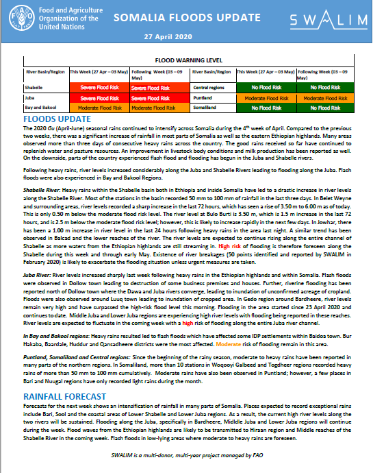
Somali Floods Update - Issued 27 April 2020
The 2020 Gu (April-June) seasonal rains continued to intensify across Somalia during the 4th week of April. Compared to the previous two weeks, there was a significant increase of rainfall in most parts of Somalia as well as the eastern Ethiopian highlands. Many areas observed more than three days of consecutive heavy rains across the country. The good rains received so far have continued to replenish water and pasture resources. An improvement in livestock body conditions and milk production has been reported as well. On the downside, parts of the country experienced flash flood and flooding has begun in the Juba and Shabelle rivers.
Following heavy rains, river levels increased considerably along the Juba and Shabelle Rivers leading to flooding along the Juba. Flash floods were also experienced in Bay and Bakool Regions.
Shabelle River: Heavy rains within the Shabelle basin both in Ethiopia and inside Somalia have led to a drastic increase in river levels along the Shabelle River. Most of the stations in the basin recorded 50 mm to 100 mm of rainfall in the last three days. In Belet Weyne and surrounding areas, river levels recorded a sharp increase in the last 72 hours, which has seen a rise of 3.50 m to 6.00 m as of today. This is only 0.50 m below the moderate flood risk level. The river level at Bulo Burti is 3.50 m, which is 1.5 m increase in the last 72 hours, and is 2.5 m below the moderate flood risk level; however, this is likely to increase rapidly in the next few days. In Jowhar, there has been a 1.00 m increase in river level in the last 24 hours following heavy rains in the area last night. A similar trend has been observed in Balcad and the lower reaches of the river. The river levels are expected to continue rising along the entire channel of Shabelle as more waters from the Ethiopian highlands are still streaming in. High risk of flooding is therefore foreseen along the Shabelle during this week and through early May. Existence of river breakages (50 points identified and reported by SWALIM in February 2020) is likely to exacerbate the flooding situation unless urgent measures are taken.
Juba River: River levels increased sharply last week following heavy rains in the Ethiopian highlands and within Somalia. Flash floods were observed in Dollow town leading to destruction of some business premises and houses. Further, riverine flooding has been reported north of Dollow town where the Dawa and Juba rivers converge, leading to inundation of unconfirmed acreage of cropland. Floods were also observed around Luuq town leading to inundation of cropped area. In Gedo region around Bardheere, river levels remain very high and have surpassed the high-risk flood level this morning. Flooding in the area started since 23 April 2020 and continues to date. Middle Juba and Lower Juba regions are experiencing high river levels with flooding being reported in these reaches. River levels are expected to fluctuate in the coming week with a high risk of flooding along the entire Juba river channel.
In Bay and Bakool regions: Heavy rains resulted led to flash floods which have affected some IDP settlements within Baidoa town. Bur Hakaba, Baardale, Huddur and Qansadheere districts were the most affected. Moderate risk of flooding remain in this area.
Puntland, Somaliland and Central regions: Since the beginning of the rainy season, moderate to heavy rains have been reported in many parts of the northern regions. In Somaliland, more than 10 stations in Woqooyi Galbeed and Togdheer regions recorded heavy rains of more than 50 mm to 100 mm cumulatively. Moderate rains have also been observed in Puntland; however, a few places in Bari and Nuugal regions have only recorded light rains during the month.
Publication Type:
Flood watch bulletin
Publication Date:
Author:
Corporate Author:
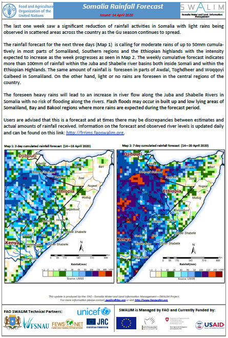
Somalia Rainfall Forecast - Issued 14 April 2020
The last one week saw a significant reduction of rainfall activities in Somalia with light rains being observed in scattered areas across the country as the Gu season continues to spread.
The rainfall forecast for the next three days is calling for moderate rains of up to 50mm cumulatively in most parts of Somaliland, Southern regions and the Ethiopian highlands with the intensity expected to increase as the week progresses. The weekly cumulative forecast indicates more than 100mm of rainfall within the Juba and Shabelle river basins both inside Somali and within the Ethiopian Highlands. The same amount of rainfall is foreseen in parts of Awdal, Toghdheer and Woqqoyi Galbeed in Somaliland. On the other hand, light or no rains are foreseen in the central regions of the country.
The foreseen heavy rains will lead to an increase in river flow along the Juba and Shabelle Rivers in Somalia with no risk of flooding along the rivers. Flash floods may occur in built up and low lying areas of Somaliland, Bay and Bakool regions where more rains are expected during the forecast period.
Publication Type:
Rainfall Forecast
Publication Date:
Author:
Corporate Author:
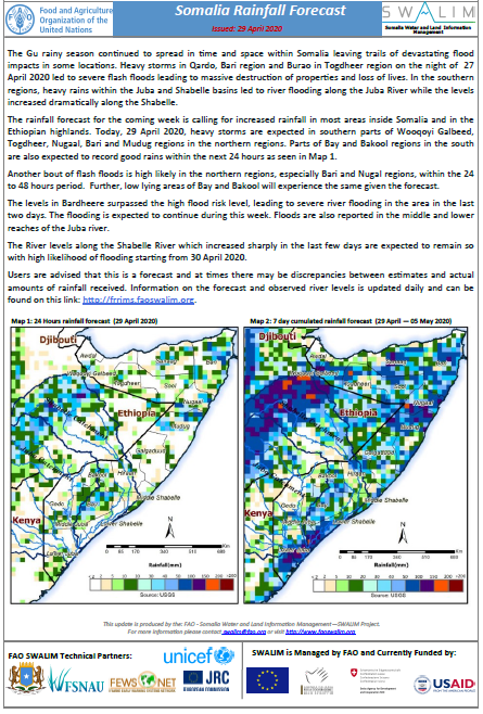
Somalia Rainfall Forecast - Issued 29 April 2020
The Gu rainy season continued to spread in time and space within Somalia leaving trails of devastating flood impacts in some locations. Heavy storms in Qardo, Bari region and Burao in Togdheer region on the night of 27 April 2020 led to severe flash floods leading to massive destruction of properties and loss of lives. In the southern regions, heavy rains within the Juba and Shabelle basins led to river flooding along the Juba River while the levels increased dramatically along the Shabelle.
The rainfall forecast for the coming week is calling for increased rainfall in most areas inside Somalia and in the Ethiopian highlands. Today, 29 April 2020, heavy storms are expected in southern parts of Wooqoyi Galbeed, Togdheer, Nugaal, Bari and Mudug regions in the northern regions. Parts of Bay and Bakool regions in the south are also expected to record good rains within the next 24 hours.
Another bout of flash floods is high likely in the northern regions, especially Bari and Nugal regions, within the 24 to 48 hours period. Further, low lying areas of Bay and Bakool will experience the same given the forecast.
The levels in Bardheere surpassed the high flood risk level, leading to severe river flooding in the area in the last two days. The flooding is expected to continue during this week. Floods are also reported in the middle and lower reaches of the Juba river.
The River levels along the Shabelle River which increased sharply in the last few days are expected to remain so with high likelihood of flooding starting from 30 April 2020.
Publication Type:
Rainfall Forecast
Publication Date:
Author:
Corporate Author:
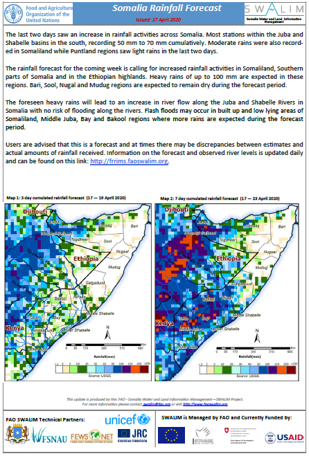
Somalia Rainfall Forecast - Issued 17 April 2020
The last two days saw an increase in rainfall activities across Somalia. Most stations within the Juba and Shabelle basins in the south, recording 50 mm to 70 mm cumulatively. Moderate rains were also recorded in Somaliland while Puntland regions saw light rains in the last two days.
The rainfall forecast for the coming week is calling for increased rainfall activities in Somaliland, Southern parts of Somalia and in the Ethiopian highlands. Heavy rains of up to 100 mm are expected in these regions. Bari, Sool, Nugal and Mudug regions are expected to remain dry during the forecast period.
The foreseen heavy rains will lead to an increase in river flow along the Juba and Shabelle Rivers in Somalia with no risk of flooding along the rivers. Flash floods may occur in built up and low lying areas of Somaliland, Middle Juba, Bay and Bakool regions where more rains are expected during the forecast period.
Publication Type:
Rainfall Forecast
Publication Date:
Author:
Corporate Author:
Saadaasha Roob-di’idda Soomaaliya – 17/4/2020
Toddobaakii la soo dhaafay waxaa la arkayey kororka roob-di’idda guud ahaan Soomaaliya. Meelo badan oo ku yaal dooxooyinka Juba iyo Shabeelle ee Koonfurta, waa la diiwaaniyey 50 mm ilaa 70 mm wadar ahaan. Roobab dhexdhexaad ayaa sidoo kale laga diiwaaniyey gudaha Soomaliland halka ay Puntland ka ahaayeen roobab fudfudud labadii maalin ee u dambeeyey.
Saadaasha roob-di’idda toddobaadka soocda waxay sheegaysaa roobabka oo kordhaya gudaha Soomaaliland, qaybaha koonfureed ee Soomaaliya iyo gudaha buuraleyda Itoobiya. Roobab culculus oo gaara ilaa 100 mm ayaa laga filayaa gudaha gobolladaan. Gobollada Bari, Nugaal iyo Mudug waxaa la filayaa inay ahaadaan kuwo engegan inta lagu jiro muddada saadaashan.
Roobabka culculus ee la saadaalinayo waxay horseedi doontaa koror ku yimaadaheerka qulqulka webiyada Juba iyo Shabeelle gudaha Soomaaliya oo lahayn halis fataadeed jiidda webiyada. Daadad ka soo rogmada meelaha sarsare oo saameeya meelaha hooseeya ee gobollada Soomaaliland, Jubada Dhexe, Bay iyo Bakool oo ayaa laga filayaa meelaha roobaka culculus ku da’aan inta lagu jiro muddada la saadaalinayo.
Publication Type:
Rainfall Forecast
Publication Date:
Author:
Corporate Author:
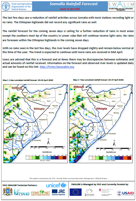
Somalia Rainfall Forecast - Issued 01 April 2020
The last few days saw a reduction of rainfall activities across Somalia with most stations recording light or no rains. The Ethiopian highlands did not record any significant rains as well.
The rainfall forecast for the coming seven days is calling for a further reduction of rains in most areas except the southern most tip of the country in Lower Juba that will continue receive light rains. No rains are foreseen within the Ethiopian highlands in the coming seven days.
With no rains seen in the last few days, the river levels have dropped slightly and remain below normal at this time of the year. The trend is expected to continue until more rains are received in Mid April.
Publication Type:
Publication Date:
Author:
Corporate Author:
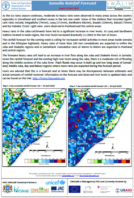
Somalia Rainfall Forecast - Issued 20 April 2020
As the Gu rainy season continues, moderate to heavy rains were observed in many areas across the country especially in Somaliland and southern areas in the last one week. Some of the stations that recorded significant rains include; Mogadishu (76mm), Luuq (172mm), Bardheere 68(mm), Buaale (130mm), Balcad (75mm) and Bur Hakaba 71mm. Light rains were observed in Puntland and the central areas.
Heavy rains in the Juba catchments have led to a significant increase in river levels. At Luuq and Bardheere stations located in Gedo region, the river levels increased drastically (+1.00m) in the last 24 hours.
The rainfall forecast for the coming week is calling for increased rainfall activities in most areas inside Somalia and in the Ethiopian highlands. Heavy rains of more than 100 mm cumulatively are expected in within the Juba and Shabelle regions and in Somaliland. Cumulative rains of 40mm to 60mm are expected in Puntland and central regions.
The foreseen heavy rains will lead to an increase in river flow along the Juba and Shabelle Rivers in Somalia. Given the rainfall forecast and the existing high river levels along the Juba, there is a moderate risk of flooding along the Middle sections of the Juba River. Flash floods may occur in built up and low lying areas of Somaliland, Middle Juba, Bay and Bakool regions where more rains are expected during the forecast period.
Publication Type:
Rainfall Forecast
Publication Date:
Author:
Corporate Author:
Saadaasha Roob-di’idda Soomaaliya - 01 April 2020
Dhowrkii maalin oo dambe roob-di’iddii waa yaraatay guud ahaan Soomaaliya iyadoo xarumaha badankood ay diiwaangeliyeen roobab fudfud ama roob la’aan. Sidoo kaleb Buuraleyda sare ee Itoobiya qudheedu ma aysan diiwaangelin roobab macna leh.
Saadaasha roob-di’idda ee todobada maalin oo socota waxay leedahay roobabku waa sii yaraanayaan meelaha intooda badan marka laga reebo koonfurta cirifika u dambeeya dalka gudaha Jubada Hoose halkaas oo ay ka sii socon doonaan roobab fudfud. Ma jiraan roobab laga odorosayo gudaha buuraleyda Itoobiya toddobada maalin ee soo socota.
Roobab la’aanta la arkay dhowrkii maalin oo dambe, waxay keentay in heerarka webigu ay hoos u yara dhacaan oo ay gaaraan heer caadiga ka hooseysa waqtigaan kale sanadka. Waxaa la filayaa in xaaladda ay sidaas ku sii socoto ilaa roobab la helo bartamaha Abriil.
Macaamiisha waxaa lala socodsiinayaa in tani tahay saadaal oo marmarka qaarkood ay kala duwanaadaan qiyaasaha iyo xaddiyada dhabta ah ee roobabka la helay. Macluumaadka saadaasha iyo heerarka webiga la arko waxaa loo cusboonaysinayaa si maalinle ah oo waxaa laga heli karaa xiriir kan: http://frrims.faoswalim.org.
Publication Type:
Rainfall Outlook
Publication Date:
Author:
Corporate Author:
Update of analysis of very high-resolution satellite images to generate information on the charcoal production and its dynamics in South Somalia from 2011 to 2019
Charcoal is made by burning wood in a low-oxygen environment. According to FAO statistics, Africa accounts for 55% of the global charcoal production (FAO, 2014). However, these charcoal production estimates are often inaccurate when disaggregated at the national level. For many African countries, detailed information is lacking partly due to the informality and clandestine nature of production sector and the scattered production by rural population (Mwampamba et al, 2013). Estimates are consequently based on analytical and projection models that use woodfuel information of countries in similar socioeconomic and geographical situations, or by multiplying the country population by a per capita estimate
Publication Type:
Technical report
Publication Date:
Author:
Corporate Author:
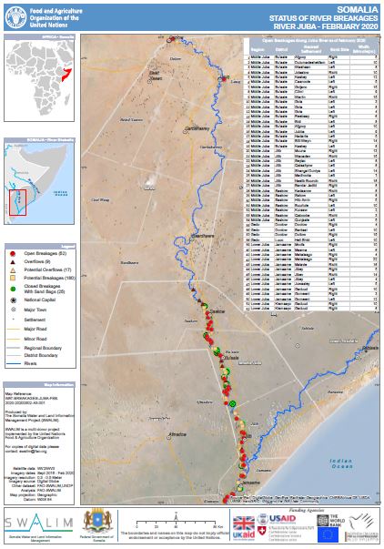
Status of River Breakages Along Juba and Shabelle Rivers - Issued March 2020
The Food and Agriculture Organization’s Somalia Water and Land Information Management (FAO SWALIM) Project, has finalized the analysis and mapping of the river breakages along the Juba and Shabelle rivers using very high resolution satellite imagery. Breakages identified in the map have been classified into five different categories; Open, Overflow, Potential Overflows, Potential breakages and Closed with sandbags. A legend/Key for further explanation of the different types of breakages is provided here.
The heavy rains during the Deyr 2019 rainy season led to increased flow causing overflow and riverbank breakages in sections of the two rivers. Henceforth, there was an increase of the open points from the previous assessment of August 2019.
A total of 152 Open points have been identified, 100 on the Shabelle River and 52 on the Juba River which require immediate attention. Several other points, which are either potential or temporarily closed with sandbags, have also been identified.
The Gu 2020 rainfall outlook is calling for enhanced rains within the Juba and Shabelle Rivers as well as the Ethiopian highlands. Consequently, river levels are expected to increase with a high likelihood of flooding especially where open and potential points have been identified.
There is therefore an immediate need to close the open points and reinforce areas where there are weak river embankments. Intervening agencies are advised to take advantage of the current dry period until the rains start and carry out temporary or long term measures to close the river breakages. This will see a reduction of riverine flooding in case of heavy rains and consequently a massive reduction in economic losses to the country.
SWALIM is pleased to share with you maps and tables of the status of river breakages along the two rivers. Hardcopies can be obtained from FAO SWALIM offices.
It is worth noting that the methodology is biased towards Remote Sensing (RS) interpretation with only limited “ground truthing” due to constraints in accessing the areas. Open breakages and overflows might have been omitted or classified as potential in some cases where satellite images were not available or may not have been very clear due to heavy cloud cover and dense vegetation cover.
Publication Type:
Map
Publication Date:
Author:
Corporate Author:
Pages
 RSS feed [compliant with the Agris AP] |
  Agris AP XML