Library Catalog
Latest Documents and Publications listed. Use search terms in the box below to find what you need
Somalia Rainfall Forecast – Issued 04 October 2021
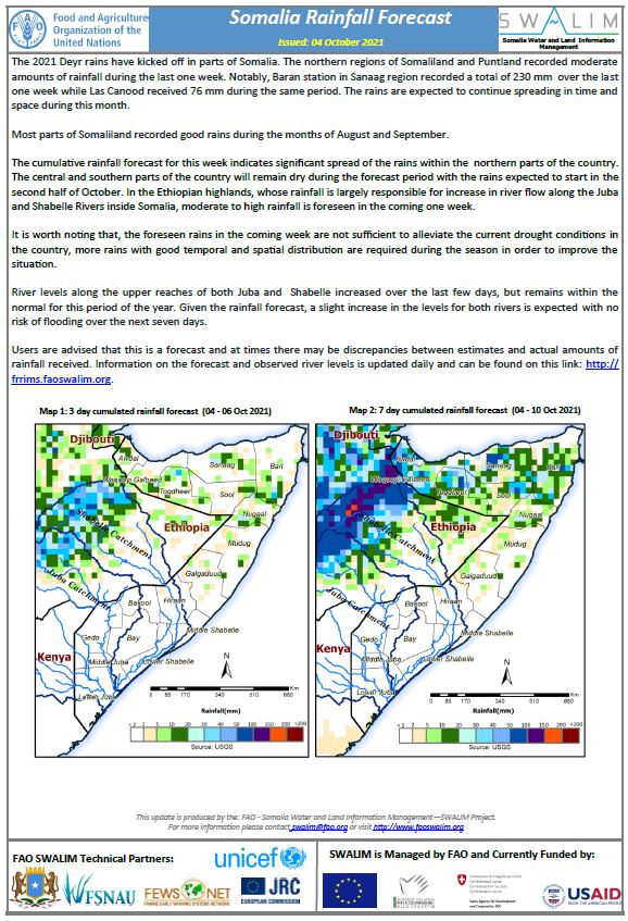
The 2021 Deyr rains have kicked off in parts of Somalia. The northern regions of Somaliland and Puntland recorded moderate amounts of rainfall during the last one week. Notably, Baran station in Sanaag region recorded a total of 230 mm over the last one week while Las Canood received 76 mm during the same period. The rains are expected to continue spreading in time and space during this month.
Most parts of Somaliland recorded good rains during the months of August and September.
The cumulative rainfall forecast for this week indicates significant spread of the rains within the northern parts of the country. The central and southern parts of the country will remain dry during the forecast period with the rains expected to start in the second half of October. In the Ethiopian highlands, whose rainfall is largely responsible for increase in river flow along the Juba and Shabelle Rivers inside Somalia, moderate to high rainfall is foreseen in the coming one week.
It is worth noting that, the foreseen rains in the coming week are not sufficient to alleviate the current drought conditions in the country, more rains with good temporal and spatial distribution are required during the season in order to improve the situation.
River levels along the upper reaches of both Juba and Shabelle increased over the last few days, but remains within the normal for this period of the year. Given the rainfall forecast, a slight increase in the levels for both rivers is expected with no risk of flooding over the next seven days.
Publication Type:
Rainfall Forecast
Publication Date:
Author:
Corporate Author:
Flood Update for Jowhar District – Issued 16 August 2021
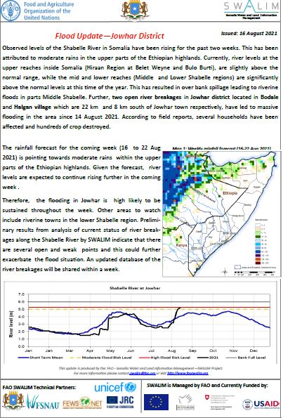
Observed levels of the Shabelle River in Somalia have been rising for the past two weeks. This has been attributed to moderate rains in the upper parts of the Ethiopian highlands. Currently, river levels at the upper reaches inside Somalia (Hiraan Region at Belet Weyne and Bulo Burti), are slightly above the normal range, while the mid and lower reaches (Middle and Lower Shabelle regions) are significantly above the normal levels at this time of the year. This has resulted in over bank spillage leading to riverine floods in parts Middle Shabelle. Further, two open river breakages in Jowhar district located in Bodale and Halgan village which are 22 km and 8 km south of Jowhar town respectively, have led to massive flooding in the area since 14 August 2021. According to field reports, several households have been affected and hundreds of crop destroyed.
The rainfall forecast for the coming week (16 to 22 Aug 2021) is pointing towards moderate rains within the upper parts of the Ethiopian highlands. Given the forecast, river levels are expected to continue rising further in the coming week .
Therefore, the flooding in Jowhar is high likely to be sustained throughout the week. Other areas to watch include riverine towns in the lower Shabelle region. Preliminary results from analysis of current status of river breakages along the Shabelle River by SWALIM indicate that there are several open and weak points and this could further exacerbate the flood situation. An updated database of the river breakages will be shared within a week.
Publication Type:
Flood watch bulletin
Publication Date:
Author:
Corporate Author:
Somalia Drought Update – Issued 26 August 2021
The failure of Dery 2020 (Oct- Dec) rainy season followed by a by a harsh and warmer than normal Jan-Mar Jilaal season, and a poorly distributed Gu 2021 (Mar/Apr-Jun) rainy season have led to mild to moderate drought conditions in some parts of Somalia.
The southern parts of the country including the Middle juba, Gedo and parts of Bay and Bakool have been worst affected and are experiencing moderate drought conditions.
River levels along the Juba and Shabelle rivers remained significantly below average since Mid-June and started to rise at the beginning of August following moderate rains in the upper parts of the Ethiopian highlands.
Preliminary rainfall forecast for the coming months indicates dry conditions throughout August and September in most parts of the country except Awdal region and southern coastal areas that will continue to receive the Karan rains.
According to the seasonal outlook by IGAD Climate Prediction and Application Centre (ICPAC), the Deyr 2021 rainy season is expected to be below average in most parts of the country.
Mild to moderate drought conditions are expected to persist in many parts of the country until early 2022 given the current situation and the Deyy 2021 rainfall outlook.
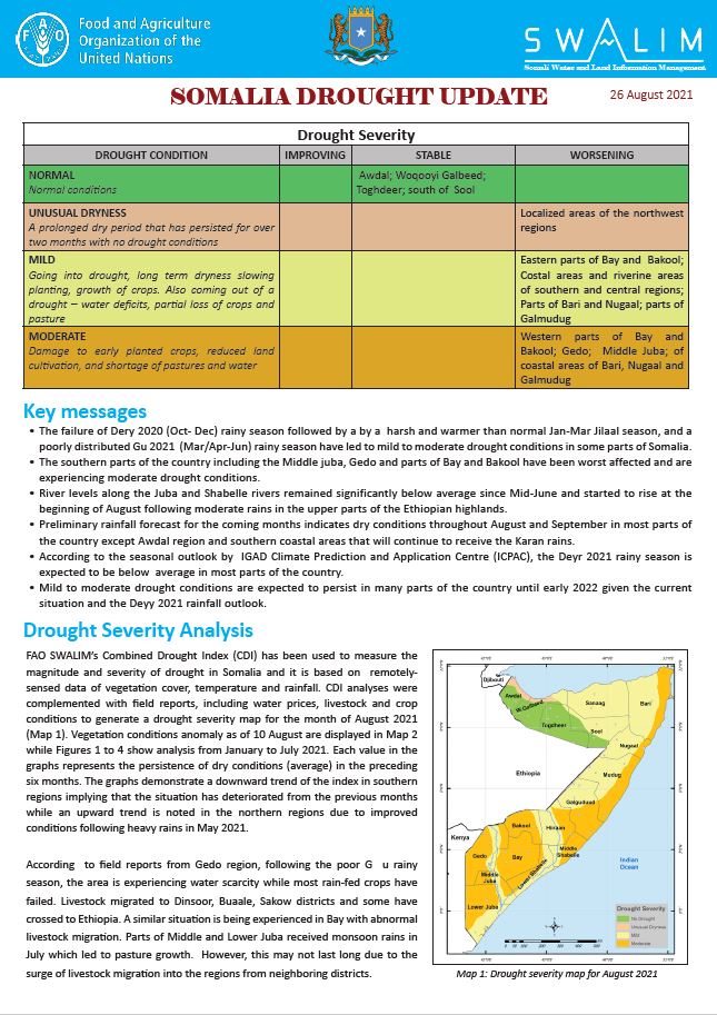
Drought Severity Analysis
FAO SWALIM’s Combined Drought Index (CDI) has been used to measure the magnitude and severity of drought in Somalia and it is based on remotely-sensed data of vegetation cover, temperature and rainfall. CDI analyses were complemented with field reports, including water prices, livestock and crop conditions to generate a drought severity map for the month of August 2021 (Map 1). Vegetation conditions anomaly as of 10 August are displayed in Map 2 while Figures 1 to 4 show analysis from January to July 2021. Each value in the graphs represents the persistence of dry conditions (average) in the preceding six months. The graphs demonstrate a downward trend of the index in southern regions implying that the situation has deteriorated from the previous months while an upward trend is noted in the northern regions due to improved conditions following heavy rains in May 2021.
Publication Type:
Drought watch
Publication Date:
Author:
Corporate Author:
Somalia River Breakages Update – August 2021
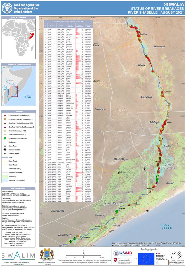
Recurrent flooding along the Juba and Shabelle Rivers in Southern Somalia has been one of the key challenges for the riverine communities. The last 10 years have seen more than six major flood events including in; 2010, 2013, 2015, 2018, 2019 and 2020. The last three events had magnitudes larger than the one associated with the historical 50-year return period flood occurrence. Such sequential events have had hazardous impacts, eroding resilience, economic reserves, health and livelihoods. Flooding and the associated effects along the two rivers has damaged vast farmland with crops and infrastructure. Soil erosion as a results of poor watershed management has gradually led to deposition of sediment into the two rivers, causing the infilling of the riverbeds and consequently raising it. For instance, in Jowhar, in Middle Shabelle, the river bed raised by close to 1.0 m since 2015. This leads to reduced capacity of the river channel and over bank spillage in flows much lower than expected.
SWALIM has been mapped twice a year the river breakages along the two rivers since 2015. This had been made possible with the use of World View Very High-Resolution (VHR) satellite imagery provided by Digital Globe. Due to lower temporal resolution of images present in Digital Globe archive, Pleiades Images provided by Airbus supplemented the image gaps in some areas. Where possible the preliminary findings from the images were verified with field observations to confirm the status of river breakages. In this case, the field river breakages surveys were carried out in Belet Weyne, Jowhar, Balcad and Afgooye districts all along the Shabelle River. In other cases, breakages which had been verified on VHR in March 2021 and there was either cloudy images or no images at all in the current assessment have been marked as ‘Not verified’.
Along the Juba River, 32 open points, 6 overflows and another 123 potential breakages and 75 potential overflows were identified. Further, 103 open points, 106 overflows and 103 potential breakages and 322 potential overflows were identified along the Shabelle River.
It has been observed that the number of points either open or overflows has been increasing over the years probably due to the continuous weakening of the river banks following three years of successive heavy floods in 2018, 2019 and 2020. These points need immediate closure or reinforcement before the 2021 Deyr rainy season which is expected to start in Mid-October 2021.
SWALIM is pleased to share with you district maps of the status of open river points along the Juba and Shabelle, which can be downloaded from the links below;
Publication Type:
Map
Publication Date:
Author:
Corporate Author:
Rainfall Performance Gu 2021 (March-June)
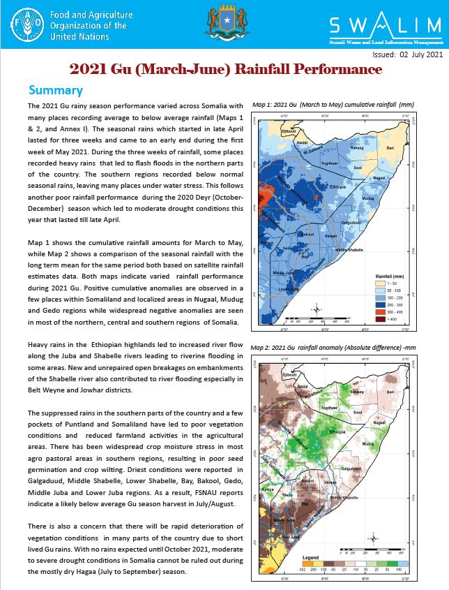
The 2021 Gu rainy season performance varied across Somalia with many places recording average to below average rainfall (Maps 1 & 2, and Annex I). The seasonal rains which started in late April lasted for three weeks and came to an early end during the first week of May 2021. During the three weeks of rainfall, some places recorded heavy rains that led to flash floods in the northern parts of the country. The southern regions recorded below normal seasonal rains, leaving many places under water stress. This follows another poor rainfall performance during the 2020 Deyr (October-December) season which led to moderate drought conditions this year that lasted till late April.
Map 1 shows the cumulative rainfall amounts for March to May, while Map 2 shows a comparison of the seasonal rainfall with the long term mean for the same period both based on satellite rainfall estimates data. Both maps indicate varied rainfall performance during 2021 Gu. Positive cumulative anomalies are observed in a few places within Somaliland and localized areas in Nugaal, Mudug and Gedo regions while widespread negative anomalies are seen in most of the northern, central and southern regions of Somalia.
Heavy rains in the Ethiopian highlands led to increased river flow along the Juba and Shabelle rivers leading to riverine flooding in some areas. New and unrepaired open breakages on embankments of the Shabelle river also contributed to river flooding especially in Belt Weyne and Jowhar districts.
The suppressed rains in the southern parts of the country and a few pockets of Puntland and Somaliland have led to poor vegetation conditions and reduced farmland activities in the agricultural areas. There has been widespread crop moisture stress in most agro pastoral areas in southern regions, resulting in poor seed germination and crop wilting. Driest conditions were reported in Galgaduud, Middle Shabelle, Lower Shabelle, Bay, Bakool, Gedo, Middle Juba and Lower Juba regions. As a result, FSNAU reports indicate a likely below average Gu season harvest in July/August.
There is also a concern that there will be rapid deterioration of vegetation conditions in many parts of the country due to short lived Gu rains. With no rains expected until October 2021, moderate to severe drought conditions in Somalia cannot be ruled out during the mostly dry Hagaa (July to September) season.
Publication Type:
Rainfall Performance
Publication Date:
Author:
Corporate Author:
Somalia Flood Update – 28 May 2021.pdf
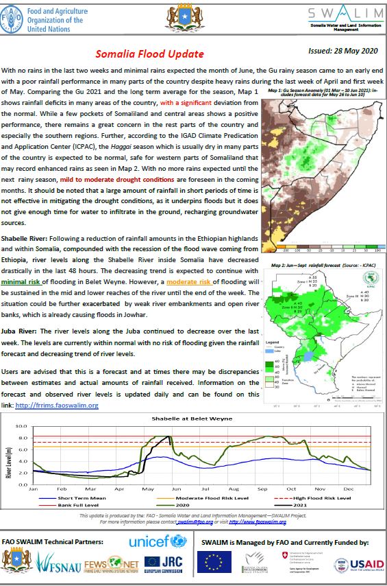
With no rains in the last two weeks and minimal rains expected the month of June, the Gu rainy season came to an early end with a poor rainfall performance in many parts of the country despite heavy rains during the last week of April and first week of May. Comparing the Gu 2021 and the long term average for the season, Map 1 shows rainfall deficits in many areas of the country, with a significant deviation from the normal. While a few pockets of Somaliland and central areas shows a positive performance, there remains a great concern in the rest parts of the country and especially the southern regions. Further, according to the IGAD Climate Predication and Application Center (ICPAC), the Haggai season which is usually dry in many parts of the country is expected to be normal, safe for western parts of Somaliland that may record enhanced rains as seen in Map 2. With no more rains expected until the next rainy season, mild to moderate drought conditions are foreseen in the coming months. It should be noted that a large amount of rainfall in short periods of time is not effective in mitigating the drought conditions, as it underpins floods but it does not give enough time for water to infiltrate in the ground, recharging groundwater sources.
Shabelle River: Following a reduction of rainfall amounts in the Ethiopian highlands and within Somalia, compounded with the recession of the flood wave coming from Ethiopia, river levels along the Shabelle River inside Somalia have decreased drastically in the last 48 hours. The decreasing trend is expected to continue with minimal risk of flooding in Belet Weyne. However, a moderate risk of flooding will be sustained in the mid and lower reaches of the river until the end of the week. The situation could be further exacerbated by weak river embankments and open river banks, which is already causing floods in Jowhar.
Juba River: The river levels along the Juba continued to decrease over the last week. The levels are currently within normal with no risk of flooding given the rainfall forecast and decreasing trend of river levels.
Publication Type:
Flood watch bulletin
Publication Date:
Author:
Corporate Author:
Flood advisory for Juba Shabelle Rivers!
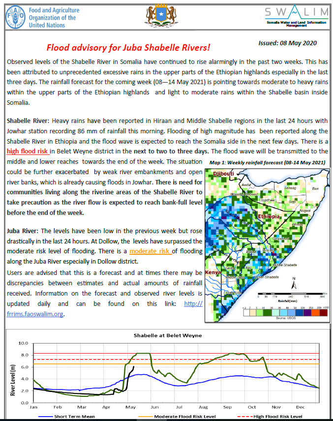
Observed levels of the Shabelle River in Somalia have continued to rise alarmingly in the past two weeks. This has been attributed to unprecedented excessive rains in the upper parts of the Ethiopian highlands especially in the last three days. The rainfall forecast for the coming week (08—14 May 2021) is pointing towards moderate to heavy rains within the upper parts of the Ethiopian highlands and light to moderate rains within the Shabelle basin inside Somalia.
Shabelle River: Heavy rains have been reported in Hiraan and Middle Shabelle regions in the last 24 hours with Jowhar station recording 86 mm of rainfall this morning. Flooding of high magnitude has been reported along the Shabelle River in Ethiopia and the flood wave is expected to reach the Somalia side in the next few days. There is a high flood risk in Belet Weyne district in the next to two to three days. The flood wave will be transmitted to the middle and lower reaches towards the end of the week. The situation could be further exacerbated by weak river embankments and open river banks, which is already causing floods in Jowhar. There is need for communities living along the riverine areas of the Shabelle River to take precaution as the river flow is expected to reach bank-full level before the end of the week.
Juba River: The levels have been low in the previous week but rose drastically in the last 24 hours. At Dollow, the levels have surpassed the moderate risk level of flooding. There is a moderate risk of flooding along the Juba River especially in Dollow district.
Publication Type:
Publication Date:
Author:
Corporate Author:
Somalia Flood Update – 10 May 2021.pdf
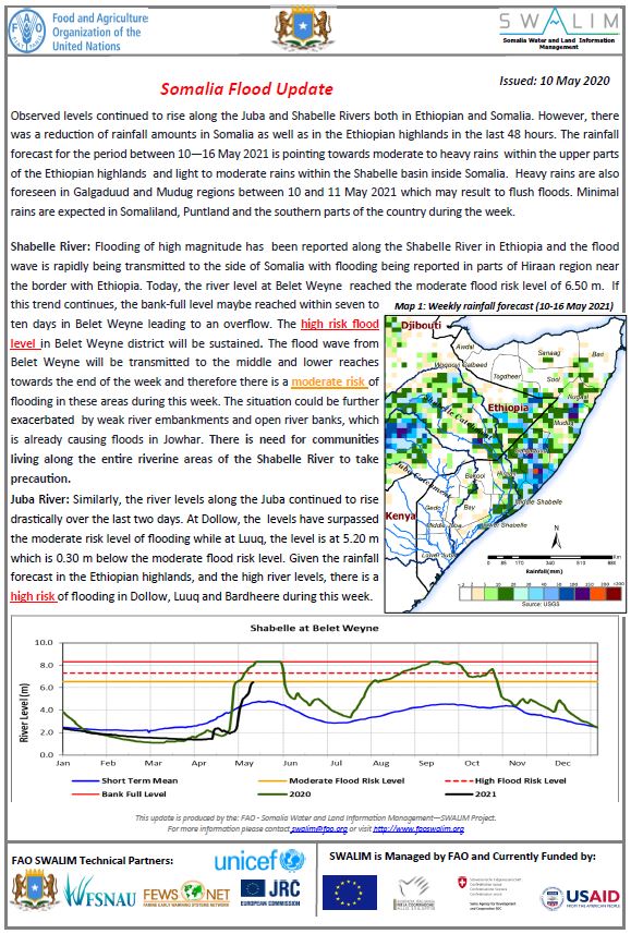
Observed levels continued to rise along the Juba and Shabelle Rivers both in Ethiopian and Somalia. However, there was a reduction of rainfall amounts in Somalia as well as in the Ethiopian highlands in the last 48 hours. The rainfall forecast for the period between 10—16 May 2021 is pointing towards moderate to heavy rains within the upper parts of the Ethiopian highlands and light to moderate rains within the Shabelle basin inside Somalia. Heavy rains are also foreseen in Galgaduud and Mudug regions between 10 and 11 May 2021 which may result to flush floods. Minimal rains are expected in Somaliland, Puntland and the southern parts of the country during the week.
Shabelle River: Flooding of high magnitude has been reported along the Shabelle River in Ethiopia and the flood wave is rapidly being transmitted to the side of Somalia with flooding being reported in parts of Hiraan region near the border with Ethiopia. Today, the river level at Belet Weyne reached the moderate flood risk level of 6.50 m. If this trend continues, the bank-full level maybe reached within seven to ten days in Belet Weyne leading to an overflow. The high risk flood level in Belet Weyne district will be sustained. The flood wave from Belet Weyne will be transmitted to the middle and lower reaches towards the end of the week and therefore there is a moderate risk of flooding in these areas during this week. The situation could be further exacerbated by weak river embankments and open river banks, which is already causing floods in Jowhar. There is need for communities living along the entire riverine areas of the Shabelle River to take precaution.
Juba River: Similarly, the river levels along the Juba continued to rise drastically over the last two days. At Dollow, the levels have surpassed the moderate risk level of flooding while at Luuq, the level is at 5.20 m which is 0.30 m below the moderate flood risk level. Given the rainfall forecast in the Ethiopian highlands, and the high river levels, there is a high risk of flooding in Dollow, Luuq and Bardheere during this week.
Publication Type:
Flood Alert
Publication Date:
Author:
Corporate Author:
Somalia Flood Update – 13 May 2021.pdf
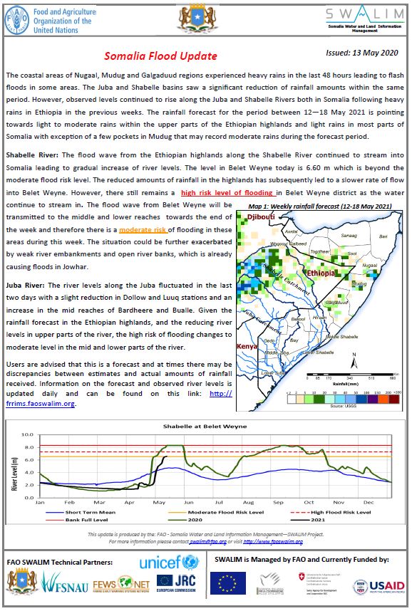
The coastal areas of Nugaal, Mudug and Galgaduud regions experienced heavy rains in the last 48 hours leading to flash floods in some areas. The Juba and Shabelle basins saw a significant reduction of rainfall amounts within the same period. However, observed levels continued to rise along the Juba and Shabelle Rivers both in Somalia following heavy rains in Ethiopia in the previous weeks. The rainfall forecast for the period between 12—18 May 2021 is pointing towards light to moderate rains within the upper parts of the Ethiopian highlands and light rains in most parts of Somalia with exception of a few pockets in Mudug that may record moderate rains during the forecast period.
Shabelle River: The flood wave from the Ethiopian highlands along the Shabelle River continued to stream into Somalia leading to gradual increase of river levels. The level in Belet Weyne today is 6.60 m which is beyond the moderate flood risk level. The reduced amounts of rainfall in the highlands has subsequently led to a slower rate of flow into Belet Weyne. However, there still remains a high risk level of flooding in Belet Weyne district as the water continue to stream in. The flood wave from Belet Weyne will be transmitted to the middle and lower reaches towards the end of the week and therefore there is a moderate risk of flooding in these areas during this week. The situation could be further exacerbated by weak river embankments and open river banks, which is already causing floods in Jowhar.
Juba River: The river levels along the Juba fluctuated in the last two days with a slight reduction in Dollow and Luuq stations and an increase in the mid reaches of Bardheere and Bualle. Given the rainfall forecast in the Ethiopian highlands, and the reducing river levels in upper parts of the river, the high risk of flooding changes to moderate level in the mid and lower parts of the river.
Publication Type:
Flood Alert
Publication Date:
Author:
Corporate Author:
Somalia Flood Update – 02 May 2021.pdf
Due to climate change and its associated impacts Somalia is now recording more wet and dry weather events, often with disastrous consequences for the people facing such extremes. It has become even more difficult to predict such sequential events. Currently, more than 80 percent of the country is facing drought conditions in the mid of the primary Gu rainy season. Yet, flash floods have been reported in the last two days following heavy and sporadic rains in Somaliland. In addition, limited climate change adaptive capacities has led to irresponsible socio-economic practices like cutting of river banks to extract irrigation waters, further exposing the communities to climate hazards. For instance, riverine flooding due to open river banks near Baarey and Moyko villages has been reported in Jowhar within Middle Shabelle region.
With current climate models predicting extreme temperatures and rainfall in the future within the region, the country is likely to continue experiencing frequent flood and drought events with likely consequences of affecting untold numbers of people, taxing economies, disrupting food production, creating unrest and prompting migrations.
Publication Type:
Flood watch bulletin
Publication Date:
Author:
Corporate Author:
Pages
 RSS feed [compliant with the Agris AP] |
  Agris AP XML