Library Catalog
Latest Documents and Publications listed. Use search terms in the box below to find what you need
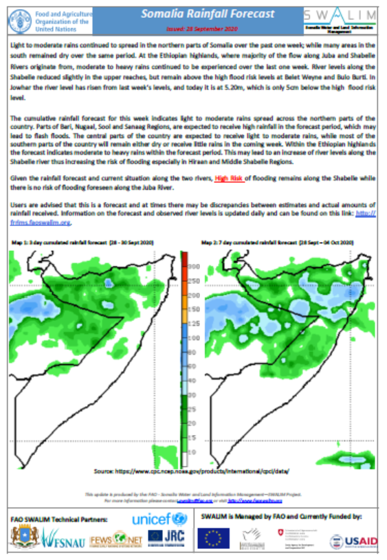
Somalia Rainfall Forecast - Issued: 28 September 2020
Light to moderate rains continued to spread in the northern parts of Somalia over the past one week; while many areas in the south remained dry over the same period. At the Ethiopian highlands, where majority of the flow along Juba and Shabelle Rivers originate from, moderate to heavy rains continued to be experienced over the last one week. River levels along the Shabelle reduced slightly in the upper reaches, but remain above the high flood risk levels at Belet Weyne and Bulo Burti. In Jowhar the river level has risen from last week’s levels, and today it is at 5.20m, which is only 5cm below the high flood risk level.
The cumulative rainfall forecast for this week indicates light to moderate rains spread across the northern parts of the country. Parts of Bari, Nugaal, Sool and Sanaag Regions, are expected to receive high rainfall in the forecast period, which may lead to flash floods. The central parts of the country are expected to receive light to moderate rains, while most of the southern parts of the country will remain either dry or receive little rains in the coming week. Within the Ethiopian highlands the forecast indicates moderate to heavy rains within the forecast period. This may lead to an increase of river levels along the Shabelle river thus increasing the risk of flooding especially in Hiraan and Middle Shabelle Regions.
Given the rainfall forecast and current situation along the two rivers, High Risk of flooding remains along the Shabelle while there is no risk of flooding foreseen along the Juba River.
Publication Type:
Rainfall Forecast
Publication Date:
Author:
Corporate Author:
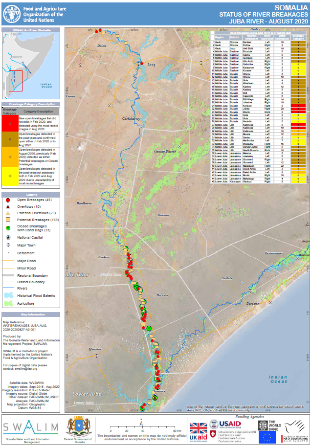
Status of River Breakages Along Juba and Shabelle Rivers - Issued September 2020
Following three consecutive significant rainy seasons, (Dery 2019, Gu 2020 and Hagaa 2020-traditionally dry) river levels along the Juba and Shabelle Rivers have remained high for a long period with flooding due to overbank spillage and existing river breakages/weak embankments. The high rains and subsequent floods of Gu 2020 saw new open river banks.
SWALIM has updated the status of the river breakages along the Juba and Shabelle Rivers using available Very High Resolution (VHR) satellite imagery and a Digital Elevation Model (DEM); supported by “limited ground truthing” field observations, where feasible.
Four types of breakages have been identified, namely; open, overflow, potential overflows and closed with sandbags. The open breakages are those that are currently open as observed on the latest VHR image available. The open breakages are further categorised into four classes in a chronological order, according to the assessment date and/or their former status as seen in the maps. All the observations reported refers to the latest suitable VHR satellite image available, which is indicated in the online database.
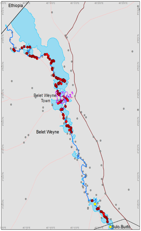
154 Open points have been identified, 109 on the Shabelle River and 45 on the Juba River which require immediate action. It is noted that several new breakages occurred during the Gu 2020 season which was exceptionally good along the two rivers. Belet Weyne district was worst affected along the Shabelle while Bu’aale district was worst affected along the Juba.
SWALIM has also embarked on a ground truthing survey along the Shabelle River in Jowhar, Balcad and Afgooye districts. The survey aims to monitor existing open and weak riverbanks while capturing the dimensions of each point. The findings of the survey will be key to planning and interventions on those points.
SWALIM is pleased to share with you maps and tables of the status of river breakages along the two rivers in the links below. This information is also available on the SWALIM website. Users are advised that the methodology is biased towards Remote Sensing (RS) interpretation with only limited “ground truthing” due to access constraints. Open breakages might have been omitted in some cases where satellite images may not have been very clear (e.g. heavy cloud cover) or were not available.
Publication Type:
Map
Publication Date:
Author:
Corporate Author:
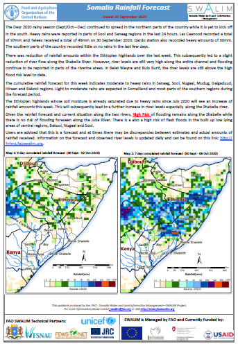
Somalia Rainfall Forecast - Issued: 30 September 2020
n the south. Heavy rains were reported in parts of Sool and Sanaag regions in the last 24 hours. Las Caanood recorded a total of 97mm and Taleex received a total of 49mm on 30 September 2020. Qardo station also recorded heavy amounts of 30mm. The southern parts of the country recorded little or no rains in the last few days.
There was reduction of rainfall amounts within the Ethiopian highlands over the last week. This subsequently led to a slight reduction of river flow along the Shabelle River. However, river levels are still very high along the entire channel and flooding continue to be reported in parts of the riverine areas. In Belet Weyne and Bulo Burti, the river levels are still above the high flood risk level to date.
The cumulative rainfall forecast for this week indicates moderate to heavy rains in Sanaag, Sool, Nugaal, Mudug, Galgaduud, Hiraan and Bakool regions. Light to moderate rains are expected in Somaliland and most parts of the southern regions during the forecast period.
The Ethiopian highlands whose soil moisture is already saturated due to heavy rains since July 2020 will see an increase of rainfall amounts this week. This will subsequently lead to a further increase in river levels especially along the Shabelle river.
Given the rainfall forecast and current situation along the two rivers, High Risk of flooding remains along the Shabelle while there is no risk of flooding foreseen along the Juba River. There is a also a high risk of flash floods in the built up low lying areas of central regions, Bakool, Nugaal and Sool.
Publication Type:
Rainfall Forecast
Publication Date:
Author:
Corporate Author:

Flood Update for River Shabelle - Issued: 08 September 2020
The upper parts of the Shabelle Basin in the Ethiopian Highlands continued to receive moderate rains during the last week. High river levels along the entire channel of Shabelle River also persisted with an increase of flood extents in Belet Weyne and Jalalaqsi districts.
Today, 08 September, the river level at Belet Weyne is bank-full and there has been overbank spillage in parts of the town. Thousands of people have been displaced and have started to evacuate from high-risk areas to low risk areas since yesterday. In Bulo Burti, the river level is at high risk level of 7.00m and is expected to increase further. The river level at Jowhar remains high and is at 4.90m as of today. Flooding is currently reported also in Jalaalaqsi.
The rainfall forecast for the week ending on 14 September 2020 indicates moderate rains in the Ethiopian highlands and minimal rains inside Somalia. Therefore, the levels are expected to continue rising along the entire channel of Shabelle as more waters from the eastern Ethiopian highlands are still streaming in. High risk of flooding is foreseen along the Shabelle during this week. It is advisable that riverine communities within low-lying areas of Belet Weyne who have not evacuated yet to do so, while following guidelines by the local authorities. Existence of river breakages (109 points identified and reported by SWALIM in Septemebr 2020) along the Shabelle is likely to exacerbate the flooding.
Publication Type:
Flood watch bulletin
Publication Date:
Author:
Corporate Author:
Somalia Flood Update and Analysis in BeletWeyne - Issued 16-09-2020
Current ongoing floods affected more than 132,000 ha of agricultural land and 294 villages in Belet Weyne, Jowhar, Balcad and Afgooye, a positive trend in flood frequency is observed in Belet Weyne, especially in the last 5 years. The severity of the floods has also gone up with time. Gu season is most vulnerable, as more floods occurred during this time, a positive trend of annual rainfall amounts has also been observed. This can be lined to climate change, but subject to further analysis,a new analysis of the status of Shabelle and Juba river was finalized by SWALIM indicates that there are 154 open river breakages which pose threat to flooding.
Publication Type:
Flood watch bulletin
Publication Date:
Author:
Corporate Author:

Flood Update for Shabelle River - Issued 13 August 2020
During the last week, there was a reduction of rainfall amounts in the southern parts of Somalia. On 11th August, a heavy storm was observed in Somaliland in Salaxley area, about 60km south of Hargeisa. The rainfall station in that area recorded a total of 44mm in less than 24 hours. This led to a significant damage of infrastructure including schools, houses, roads, electricity and interruption of communication network in the area.
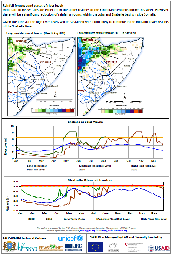
Moderate to heavy rains persisted in the upper reaches of the Shabelle Basin in Ethiopia during the same period. Consequently, river levels at Belet Weyne and other stations along the Shabelle inside Somalia continued to rise. Todays’ river level at Belet Weyne is 6.85m which means less than half a meter below the high risk level of flooding.
The rainfall forecast for the coming week (13-19 August 2020) is pointing towards moderate to heavy rains within the upper parts of the Ethiopian highlands. Little or no rains are foreseen in the basin within Somalia. Observed river levels along the Shabelle River are expected to continue rising further in the coming week following the foreseen rains in the upper catchment.
Flooding along the Shabelle will be sustained in the coming week given the current situation and the foreseen rains. Areas to be monitored include Belet Weyne, Jalalaqsi, Jowhar town and its environs where the river level is near full crest, and other riverine towns in the Lower Shabelle region. The situation could be further exacerbated by weak river embankments and open river banks.
Publication Type:
Flood watch bulletin
Publication Date:
Author:
Corporate Author:
Flood Update - Issued 05 August 2020
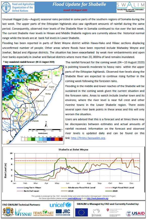
Unusual Haggai (July—August) seasonal rains persisted in some parts of the southern regions of Somalia during the last week. The upper parts of the Ethiopian highlands also saw significant amounts of rainfall during the same period. Consequently, observed river levels of the Shabelle River in Somalia continued to rise over the last week. The current Shabelle river levels in Hiraan and Middle Shabelle regions are currently above the historical normal range while the levels are at bank full levels in Lower Shabelle.
Flooding has been reported in parts of Belet Weyne district within Hawa-Hako and Hilaac sections displacing unconfirmed number of people. Other areas where floods have been reported include Mahadey Weyne and Jowhar, Balcad and Afgooye districts. The situation has been exacerbated by weak river embankments and open river banks especially in Jowhar and Balcad districts where more than 20, 000Ha of land remains inundated.
The rainfall forecast for the coming week (04—10 August 2020) is pointing towards moderate to heavy rains within the upper parts of the Ethiopian highlands. Observed river levels along the Shabelle River are expected to continue rising further in the coming week following the foreseen rains.
Flooding in the middle and lower reaches of the Shabelle will be sustained in the coming week given the current situation and the foreseen rains. Areas to watch include Jowhar town and its environs; where the river level is near full crest and other riverine towns in the Lower Shabelle region. There exists several open river bank points in these areas and this will only worsen the situation.
Publication Type:
Flood watch bulletin
Publication Date:
Author:
Corporate Author:
Flood Update for Shabelle - Issued 11 August 2020
The Ethiopian highlands have received heavy rainfall since beginning of July 2020, which has caused significant increase in Shabelle river flow in Somalia. The river level at Belet Weyne today is 6.75m surpassing the moderate level of flooding in the area. In Bulo Burti, the levels are increasing steadily and today the river level is ta 5.40m, which is 1.10m meters below the moderate risk level of flooding. Flooding has been reported in Belet Weyne district following the existence of open river bank points and weak river embankments. According to analysis based on remotely sensed data, about 11 villages have been affected by the unusual floods while 6 km2 of agricultural land has been inundated in the district. This follows another flood season (Gu 2020) that saw massive destruction of properties in the area and damage of crops. It is worth noting that the existence of open river breakages and weak river embankments have exacerbated the flooding.
Further, there has been massive sedimentation along the Shabelle River bed in the recent past, which has caused a rise in the riverbed with about 0.5 m. There are several ongoing efforts to mitigate the recurrent flooding in the district by the local communities, Hirshabelle authority and foreign aid. However, a long-term solution is needed which includes river basin management.
Publication Type:
Flood watch bulletin
Publication Date:
Author:
Corporate Author:
Gu 2020 Rainfall Performance (March to June 2020)
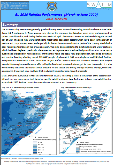
The 2020 Gu rainy season was generally good with many areas in Somalia recording normal to above normal rains (Map 1 & 2 and Annex I). There was an early start of the season in late March in some areas and continued to spread spatially with a peak during the last two weeks of April. The season came to an early end during the second half of May. The good rains were beneficial to most water dependent sectors which saw a boost in the growth of pasture and crops in many areas and especially in the north eastern and central parts of the country which had a poor rainfall performance in the previous season. The rains also contributed to significant ground water recharge which had been depleted previously. There was also an improvement in animal body conditions thus more reproduction and availability of milk and meat.
On the other hand, the heavy rains experienced in April led to both flash and riverine flooding affecting about 919 0001 people of whom 411, 905 were displaced and 24 killed. Further, along the Juba and Shabelle basins, more than 100,000 km2 of land was inundated as seen in Annex II. Belet Weyne town in Hiraan region was the worst affected by the floods and remained submerged for over two weeks. It is also worth noting that while the overall rainfall amounts for the season are mostly average to above average, there was a prolonged dry period since mid-May that is adversely impacting crop harvest prospects.
Publication Type:
Rainfall Performance
Publication Date:
Author:
Corporate Author:
Flood advisory for Lower Shabelle - Issued 24 July 2020
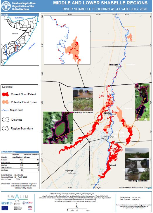
Observed river levels of the Shabelle River in Somalia have been rising for the past two weeks. This has been attributed to heavy rains in the upper parts of the Ethiopian highlands and localized rains in Lower Shabelle. The current Shabelle river levels at the upper reaches in Somalia are slightly above the historical normal range, while the lower reaches are at bank full levels. This has resulted in over bank spillage leading to riverine floods in parts of Jowhar, Balcad, Genaale and Afgooye. About 24,000Ha land is currently inundated along the Shabelle affecting over 150 villages.
The rainfall forecast for the coming week (24—30 July 2020) is pointing towards moderate to heavy rains within the upper parts of the Ethiopian highlands and within Lower Shabelle inside Somalia. Observed river levels along the Shabelle River are expected to continue rising further in the coming week following the foreseen rains.
Flooding in the middle and lower reaches of the Shabelle will be sustained in the coming week given the current situation and the foreseen rains. Areas to watch include Jowhar town and its environs; where the river level is near full crest and other riverine towns in the Lower Shabelle region. The situation could be further exacerbated by weak river embankments and open river banks.
Along the Juba river levels are within normal for this period of the year.
Publication Type:
Flood Alert
Publication Date:
Author:
Corporate Author:
Pages
 RSS feed [compliant with the Agris AP] |
  Agris AP XML